
MasterMap® is the most detailed large-scale digital mapping dataset produced by Ordnance Survey for Great Britain.
It provides highly accurate, structured vector data used by architects, planners, engineers, surveyors and infrastructure professionals for design, analysis and planning applications.
Unlike simple map images, MasterMap® is a continuously maintained geospatial dataset derived from the national mapping database.
Quick Definition
MasterMap® is a survey-accurate digital mapping product derived from the Ordnance Survey National Geographic Database (NGD), providing detailed topographic data in structured vector format.
Who Produces MasterMap®?
MasterMap® is produced by Ordnance Survey, Great Britain’s national mapping authority.
Ordnance Survey maintains a continuously updated geospatial database representing:
-
Buildings
-
Roads
-
Rail networks
-
Land parcels
-
Water features
-
Boundaries
-
Terrain
MasterMap® is generated from this database.
What Does MasterMap® Include?
The most commonly used dataset is the Topography Layer, which includes:
-
Detailed building footprints
-
Road layouts
-
Paths and physical features
-
Land boundaries
-
Surface features
Other layers may include:
-
Highways Network
-
Water Network
-
Sites Layer
-
Height and terrain data
Each mapped object is assigned a unique identifier known as a TOID (Topographic Identifier), allowing integration into GIS and asset management systems.
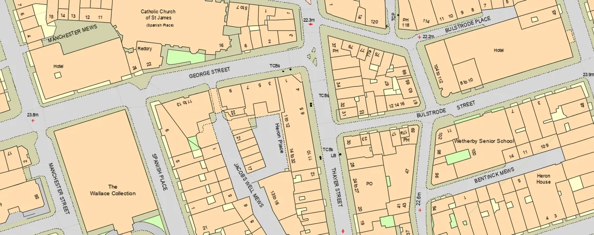
OS MasterMap® sample
How Accurate Is MasterMap®?
MasterMap® is survey-grade mapping.
It is created using:
-
Ground surveying
-
GNSS measurements
-
Aerial photography
-
LiDAR data
The dataset is continuously updated to reflect changes in the built and natural environment.
For a full explanation of how OS datasets are created, see our digital OS maps guide.
What Is MasterMap® Used For?
MasterMap® is widely used for:
-
Planning applications
-
Architectural site plans
-
Infrastructure design
-
Utilities mapping
-
Environmental assessments
-
Land referencing
Large-scale planning drawings such as 1:1250 and 1:2500 plans are typically derived from MasterMap® data.
Is MasterMap® the Same as NGD?
No.
-
The National Geographic Database (NGD) is the core national geospatial database.
-
MasterMap® is a commercial dataset derived from it.
If you want a full breakdown of the differences, see our NGD vs MasterMap® guide.
In What Formats Is MasterMap® Available?
Professionals commonly receive MasterMap® data in:
-
DWG
-
DXF
-
GIS formats
-
PDF (for planning submission use)
If you require CAD-ready files, please check our DWG maps.
Is MasterMap® Required for Planning Applications?
While not always explicitly named in guidance documents, MasterMap® is commonly used to generate compliant:
-
Location plans (1:1250 or 1:2500)
-
Block plans (1:500 or 1:200)
Using licensed Ordnance Survey-based mapping is essential for planning validation.
How Do Professionals Access MasterMap®?
Professionals do not access the raw national database directly.
Instead:
-
Ordnance Survey maintains the national geospatial database.
-
Licensed suppliers access the datasets under agreement.
-
Site-specific extracts are generated.
-
Mapping is delivered in professional formats.
You can download licensed MasterMap® extracts directly from MapServe®.
Licensing and Copyright
MasterMap® is protected by Crown copyright.
When you purchase mapping:
-
You receive a licence to use the data
-
Copyright remains with Ordnance Survey
-
Redistribution is restricted
For a full explanation of licensing requirements, see our os licensing guide.
Frequently Asked Questions
Is MasterMap® a map image?
No. It is structured vector data derived from the national geospatial database.
How often is MasterMap® updated?
It is continuously maintained to reflect changes across Great Britain.
Can I use MasterMap® in AutoCAD?
Yes. It is commonly supplied in DWG and DXF formats for CAD workflows.
Where can I download MasterMap®?
You can download licensed MasterMap® data directly from MapServe®.
Conclusion
MasterMap® is the most detailed large-scale digital mapping dataset available in Great Britain, derived from the Ordnance Survey National Geographic Database and used across planning, design and infrastructure projects.
To obtain accurate, licensed MasterMap® data for professional use, download directly from MapServe®.