Instant Download
Colour And Black & White Options
Save up to 40% vs. Other Suppliers


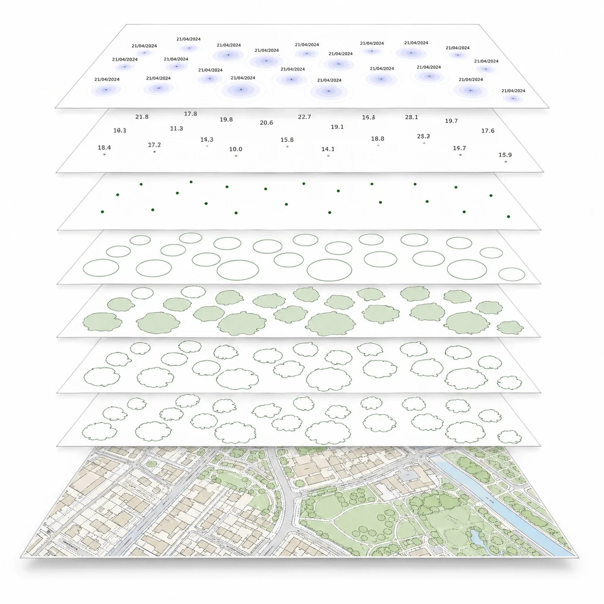
The National Tree Map™ is a detailed tree dataset created by Bluesky International. It provides the location, height and canopy/crown extent of individual trees over 3m in height across England, Wales and Scotland.
MapServe supplies the National Tree Map™ as a CAD layer alongside OS MasterMap®, helping architects, surveyors, planners, arboriculturists and environmental professionals understand existing tree cover in relation to buildings, boundaries, roads, access and site features.
The dataset is useful for early-stage feasibility, planning context, tree constraints checks, site analysis and environmental mapping. It should not be treated as a replacement for an on-site arboricultural survey where tree condition, species, root protection areas or BS5837 information is required.

| Sector | Need | Why it's used | Typical format |
|---|---|---|---|
| Architecture | Understand tree constraints around a site | Shows existing tree canopy, height and position alongside OS MasterMap® | DWG, DXF |
| Planning | Assess tree context before submission | Helps identify nearby trees that may affect design, access or planning risk | DWG, DXF |
| Surveying | Add tree context to CAD base mapping | Provides a useful reference layer before measured or arboricultural survey work | DWG, DXF |
| Arboriculture | Screen tree cover before site work | Helps identify canopy extents and tree positions for early review | DWG, DXF |
| Environmental consultancy | Map green infrastructure and canopy cover | Supports tree cover, biodiversity and environmental baseline mapping | DWG, DXF |
| Development | Early-stage site feasibility | Helps assess whether existing tree cover may influence layout, access or viability | DWG, DXF |
| Infrastructure | Route and corridor assessment | Helps assess tree cover near roads, utilities, rail and other infrastructure corridors | DWG, DXF |
| Map product | Best used for | Key limitations |
|---|---|---|
| National Tree Map™ | Existing tree location, height and canopy context in CAD | Does not provide species, condition or BS5837 survey data |
| Arboricultural survey | Planning submissions, tree constraints, condition and root protection areas | Requires site inspection and professional survey work |
| Aerial photography | Visual inspection of vegetation and site context | Does not provide structured tree height or canopy attributes |
| Topographic survey | Accurate measured site features | May not include full canopy extents or tree attributes unless specified |
| Tree Preservation Order data | Checking legal protection status | Usually local authority-specific and separate from tree canopy mapping |
The National Tree Map™ is useful for tree context and early-stage site analysis, but it is not suitable for every tree-related task.
| Attribute | Description |
|---|---|
| Coverage | England, Scotland & Wales |
| Formats | CAD (DWG & DXF) |
| Options | Colour, black & white |
| Printable scales | 1:200 – 1:10,000 |
| Accuracy | National Tree Map™ v2: over 98% of canopy coverage; over 99% within 50m of buildings |
| Updates | Regular |
| Delivery | Within seconds of ordering |
| Licence options | 12 months (other options available on request) |
| Projection | OSGB36 / British National Grid |
| Grid | British National Grid |
| Supplied with | OS MasterMap® |
| Classification criteria | Trees and bushes over 3m in height |
| Data source | Bluesky International National Tree Map™ |
| Price | From £13.72 |
| Best used for | CAD, planning context, tree constraints screening, site analysis and environmental mapping |
The National Tree Map™ is a detailed tree dataset from Bluesky International showing the location, height and canopy/crown extent of trees and bushes over 3m in height across England, Wales and Scotland.
It includes canopy polygons, idealised crown polygons and height points for trees or closely grouped tree crowns.
MapServe supplies the National Tree Map™ in CAD formats, including DWG and DXF, alongside OS MasterMap®.
National Tree Map™ data is available from MapServe from £13.72, when added to a map order.
It is useful for early planning context and tree constraints screening, but it does not replace a BS5837 arboricultural survey where one is required.
No. It shows tree location, height and canopy/crown extent. Tree Preservation Order information should be checked separately with the relevant local authority.
Bluesky states that National Tree Map™ v2 has accuracy of over 98% of canopy coverage, and over 99% within 50m of buildings.
It includes trees and bushes over 3m in height. Lower vegetation may not be included.
No. It is useful for desktop assessment and CAD context, but it should not replace an arboricultural survey where site-specific tree condition, species, root protection areas or planning evidence is required.
The National Tree Map™ is created and maintained by Bluesky International.


