
Digital Ordnance Survey (OS) maps come from Great Britain’s national geospatial database, maintained and continuously updated by Ordnance Survey using ground surveying, aerial photography, LiDAR, and remote sensing technologies.
When professionals download OS MasterMap®, 1:1250 or 1:2500 maps in DWG, DXF or PDF format, they are accessing licensed extracts of this authoritative national dataset.
This article explains exactly how that process works — from survey to downloadable file.
Quick Answer
Digital OS maps are created and maintained by Ordnance Survey using:
-
Ground-based survey measurements
-
GNSS and total station data capture
-
High-resolution aerial photography
-
LiDAR scanning
-
Continuous change detection and database updates
The data is stored in the OS National Geographic Database (NGD) and distributed via licensed suppliers such as MapServe.
The Foundation: The OS National Geographic Database (NGD)
Modern OS mapping is not drawn manually as static “maps.”
Instead, Ordnance Survey maintains a structured geospatial database called the National Geographic Database (NGD).
This database contains object-level geographic information for:
-
Buildings
-
Roads
-
Railways
-
Water features
-
Land parcels
-
Boundaries
-
Terrain
Each mapped feature exists as structured vector data, not as an image.
Products such as OS MasterMap® are derived from this database.
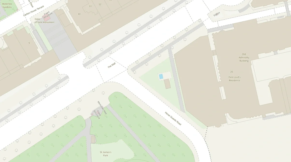
OS NGD sample
How Ordnance Survey Collects Data
1. Ground Surveying
Although much data is now captured digitally, traditional surveying remains critical.
Professional surveyors measure:
-
Building footprints
-
Infrastructure changes
-
Transport networks
-
Property extents
They use:
-
GNSS (Global Navigation Satellite Systems)
-
Total stations
-
High-precision measurement instruments
This ensures survey-grade positional accuracy.
2. Aerial Photography
Ordnance Survey captures high-resolution aerial imagery across Great Britain.
This allows mapping teams to:
-
Detect new construction
-
Identify demolitions
-
Verify structural changes
-
Update land features
Aerial imagery provides broad coverage and rapid change detection.
3. LiDAR and Remote Sensing
LiDAR (Light Detection and Ranging) is used to generate highly detailed elevation data.
This produces:
-
Digital Terrain Models (DTM)
-
Height datasets
LiDAR is essential for:
-
Flood modelling
-
Infrastructure planning
-
Environmental assessments
-
Engineering design
Continuous Updating: Why OS Data Is Trusted
Unlike static maps, OS data is continuously maintained.
When changes occur — such as:
-
New housing developments
-
Road realignments
-
Demolitions
-
Infrastructure upgrades
They are incorporated into the national database.
This continuous update model is why OS MasterMap® is relied upon for:
-
Planning applications
-
Civil engineering
-
Utilities mapping
-
Asset management
-
Large-scale development projects
Accuracy and currency are critical in professional environments.
What Is OS MasterMap®?
OS MasterMap® is the most detailed large-scale digital mapping dataset available in Great Britain.
It is:
-
Vector-based
-
Object-structured
-
Layered by theme
-
Survey-accurate
Each feature within OS MasterMap® has a unique identifier (TOID – Topographic Identifier), allowing:
-
GIS integration
-
Asset tracking
-
Change monitoring
-
Data linking across systems
MasterMap® is the primary dataset used for detailed site design and planning workflows.
From National Dataset to Downloadable Map File
Professionals rarely access the raw national database directly.
Instead, the distribution process works as follows:
-
Ordnance Survey maintains and updates the NGD.
-
Licensed partners access datasets under commercial agreements.
-
Site-specific extracts are generated.
-
Data is delivered in professional formats such as DWG, DXF or PDF.
When you download OS maps from MapServe®, you are receiving a licensed extract of authoritative OS data, formatted for immediate use in CAD or GIS software.
How 1:1250 and 1:2500 Maps Are Produced
The commonly used planning scales — 1:1250 and 1:2500 — are derived from large-scale OS datasets.
They represent:
-
Defined spatial extents
-
Accurate building footprints
-
Road networks
-
Site context
These form the basis of professional planning maps used in applications.
Unlike screenshots or consumer maps, they originate from licensed OS data and comply with professional requirements.
Are Digital OS Maps the Same as Google Maps?
No.
Google Maps and similar consumer platforms prioritise:
-
Navigation
-
User interface simplicity
-
Visual readability
Ordnance Survey datasets prioritise:
-
Positional accuracy
-
Object-level detail
-
Legal defensibility
-
Planning compliance
-
Structured geospatial data
For professional applications, only licensed OS mapping is appropriate.
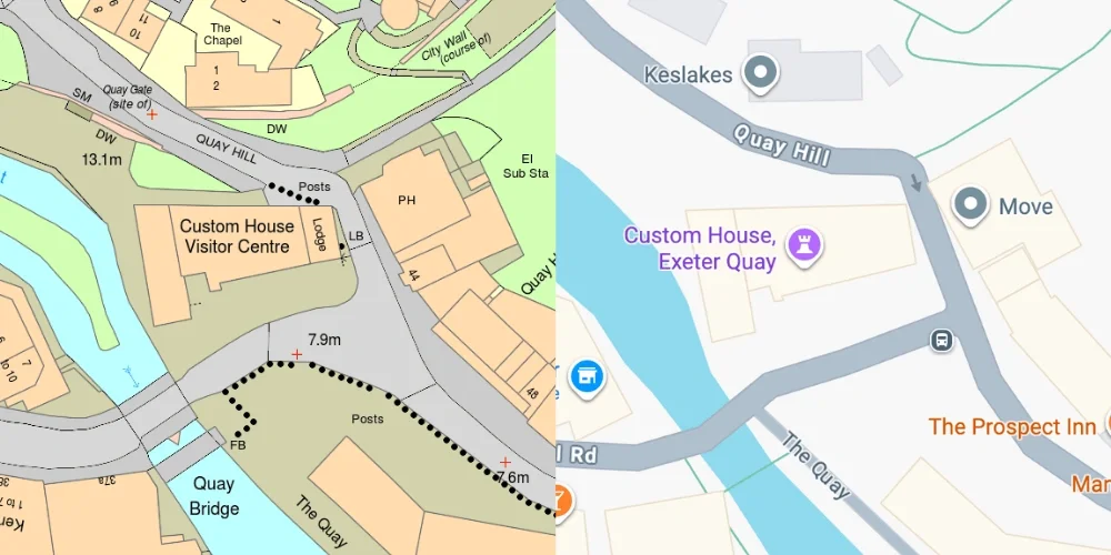
OS MasterMap® Google Maps
Licensing and Legal Framework
Digital OS maps are copyrighted products.
When you purchase OS mapping:
-
You receive a licence to use the data
-
Copyright remains with Ordnance Survey
-
Usage must comply with licence terms
Licensed suppliers manage distribution and ensure compliant access.
Why Understanding the Source Matters
Knowing where digital OS maps come from clarifies why they are:
-
Legally defensible
-
Trusted in planning submissions
-
Accepted by local authorities
-
Integrated into engineering workflows
-
Used by architects and consultants
They are not generic digital drawings. They are structured national geospatial data.
Frequently Asked Questions
Where do digital OS maps come from?
They originate from Ordnance Survey’s National Geographic Database, built using ground surveys, aerial photography, and LiDAR, and maintained as a continuously updated geospatial dataset.
Is OS MasterMap® created from satellite imagery?
Partially. OS uses aerial imagery and remote sensing, but also ground survey data and structured geospatial modelling.
Are OS maps updated regularly?
Yes. Ordnance Survey maintains a continuous update cycle to reflect changes in the built and natural environment.
Can I download OS maps instantly?
Yes. Licensed suppliers such as MapServe® provide instant downloads of OS MasterMap® and large-scale mapping in DWG, DXF and PDF formats.
Conclusion
Digital OS maps are not simple images.
They are structured, survey-accurate extracts from Great Britain’s authoritative geospatial database — built using ground measurement, aerial imagery, LiDAR and continuous data maintenance.
When you download OS MasterMap® or large-scale OS mapping, you are accessing nationally maintained geographic data trusted across planning, engineering and infrastructure sectors.
If you need licensed Ordnance Survey digital mapping, you can download OS maps instantly from MapServe®.