Tree constraints can change the outcome of a planning application before a design reaches submission stage.
For architects, planning consultants and developers, a Tree Preservation Order is not just an environmental note. It can affect layout, access, drainage, demolition, construction methods and the evidence required to support a planning application.
A TPO protects specific trees, groups of trees or woodland. Government guidance explains that protected trees cannot normally be cut down, uprooted, topped, lopped, damaged or destroyed without permission. In planning terms, that means a protected tree can become a material project constraint.
That is why TPO maps should be checked before a planning application is prepared, not after the drawings are complete.
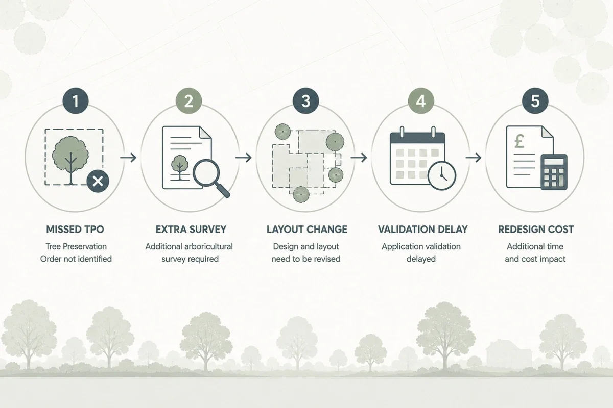
The planning risk of missing a TPO
A missed TPO can cause several problems.
The design may need to change if the protected tree conflicts with the proposed building footprint, access route or excavation zone. The application may require an arboricultural report, tree constraints plan or method statement. The local authority may ask for additional information, delaying validation or assessment.
In the worst cases, the team may have to redesign around a constraint that could have been identified during feasibility.
For commercial projects, the cost is not just the extra report. It is the knock-on impact on programme, consultant time, client confidence and viability.
Why TPO maps are useful for architects
Architects need spatial information. A written note that a TPO exists is useful, but it does not show whether the protected tree affects the footprint, boundary, access or proposed works.
A TPO map helps architects:
- understand tree constraints in relation to the site
- identify potential conflicts before drawing layouts
- avoid placing buildings too close to protected trees
- plan access and servicing routes with fewer surprises
- brief arboricultural consultants earlier
- support cleaner planning submissions
This is especially useful on constrained urban sites, garden plots, backland development, infill schemes and extensions.
Why TPO maps are useful for planning consultants
Planning consultants need to identify risk early and explain it clearly to clients.
A TPO map supports:
- initial site appraisals
- planning constraints reviews
- pre-application advice
- validation checks
- consultant briefing
- evidence gathering
- planning strategy
It also helps distinguish between different types of tree-related risk. A site may have a TPO, be in a conservation area, contain significant canopy cover, or sit near trees just outside the red line boundary. These are related issues, but they are not the same.
Why TPO maps are useful for developers
For developers, the main value is risk reduction.
A protected tree can influence developable area, access, parking, drainage, build cost and saleable layout. If the issue is identified after acquisition or after design work has begun, options are more limited.
During site search or due diligence, a TPO map can help developers ask better questions:
- Are there protected trees on or near the site?
- Could the developable area be reduced?
- Is arboricultural advice needed before offer?
- Could tree constraints affect planning timescales?
- Are there other planning constraints nearby?
- Does the site need a more detailed feasibility review?
A TPO map does not replace professional judgement, but it gives the team a stronger starting point.
TPO maps and conservation areas
One common mistake is checking for TPOs but ignoring conservation areas.
Trees in conservation areas can be subject to controls even if they are not covered by a TPO. Government guidance notes that unauthorised works to trees in conservation areas can be an offence unless an exception applies.
That means a robust planning constraints check should include both:
- Tree Preservation Orders
- Conservation Areas
For heritage-sensitive sites, the review should also consider listed buildings, Article 4 Directions and other local constraints.
TPO data is improving, but it is not always simple
The Planning Data service now includes Tree Preservation Order and Tree Preservation Zone datasets. It describes TPO data as information that helps developers and applicants check whether trees are protected and inform planning applications or tree work proposals.
However, national planning data is still developing, and the Planning Data service warns that some data may be incomplete while availability and quality improve.
For professionals, this reinforces an important point: TPO mapping should be part of a wider planning intelligence workflow. It is a strong early-stage screening step, but project teams should still verify constraints where legal certainty is required.
What should a TPO planning check include?
A practical TPO check before planning submission should include:
Site boundary review
Check whether the red line boundary contains any mapped TPO features.
Neighbouring tree review
Look beyond the site boundary. Trees outside the site can still affect design, especially if canopies, roots or protection areas extend into the development zone.
Conservation area check
Confirm whether the site lies in a conservation area, as tree works may still be controlled even where no TPO is present.
Wider constraints review
Check other planning constraints at the same time, including flood risk, listed buildings, Article 4 Directions, heritage designations and environmental constraints.
Arboricultural requirement
Decide whether the project needs arboricultural input, such as a tree survey, tree constraints plan or arboricultural impact assessment.
Submission evidence
Identify whether the application needs supporting plans, reports or tree protection information.
How MapServe helps
MapServe’s Tree Preservation Order map helps professionals screen sites for protected tree constraints and understand them in context.
Instead of treating TPOs as a separate manual lookup, MapServe supports a joined-up mapping workflow. Users can combine TPO insight with OS MasterMap, National Tree Map data and wider planning constraints.
This is valuable because planning risk rarely comes from one dataset alone. A site might have protected trees, sit in a conservation area, face surface water flood risk and be close to listed buildings. Seeing these constraints together helps the project team make better decisions earlier.
That is the benefit of mapping + planning intelligence.
Suggested workflow before submission
Before submitting a planning application, project teams should:
- Check the site using a TPO map.
- Review conservation area status.
- Add tree canopy and height context where useful.
- Check wider planning constraints.
- Identify whether arboricultural evidence is required.
- Adjust the layout before submission if needed.
- Keep a record of the constraint review.
This workflow is quicker and cheaper than discovering the issue after validation comments or objections.
Key takeaway
A TPO map is not just a tree works tool. It is a planning risk tool.
For architects, planners, surveyors and developers, checking TPOs before a planning application can help prevent avoidable redesign, support better consultant briefs and reduce the chance of late-stage planning delays.
Check protected tree constraints with MapServe’s TPO map for planning applications
FAQs
Do I need to check TPOs before submitting a planning application?
Yes. If protected trees affect the site or nearby land, they may influence layout, reports and planning evidence.
Can a TPO affect a development even if the tree is outside the site?
Yes. Nearby protected trees can still influence access, excavation, foundations and construction methods.
Does a TPO map replace an arboricultural survey?
No. A TPO map helps with early screening. A professional arboricultural survey may still be required.
Should I check conservation areas as well as TPOs?
Yes. Trees in conservation areas can be subject to controls even where no TPO is shown.
What is the best TPO check for architects?
Architects usually benefit from a map-based TPO check that shows protected trees in relation to site boundaries, buildings, access and wider planning constraints.