Instant Download
Colour And Black & White Options
Save up to 40% vs. Other Suppliers


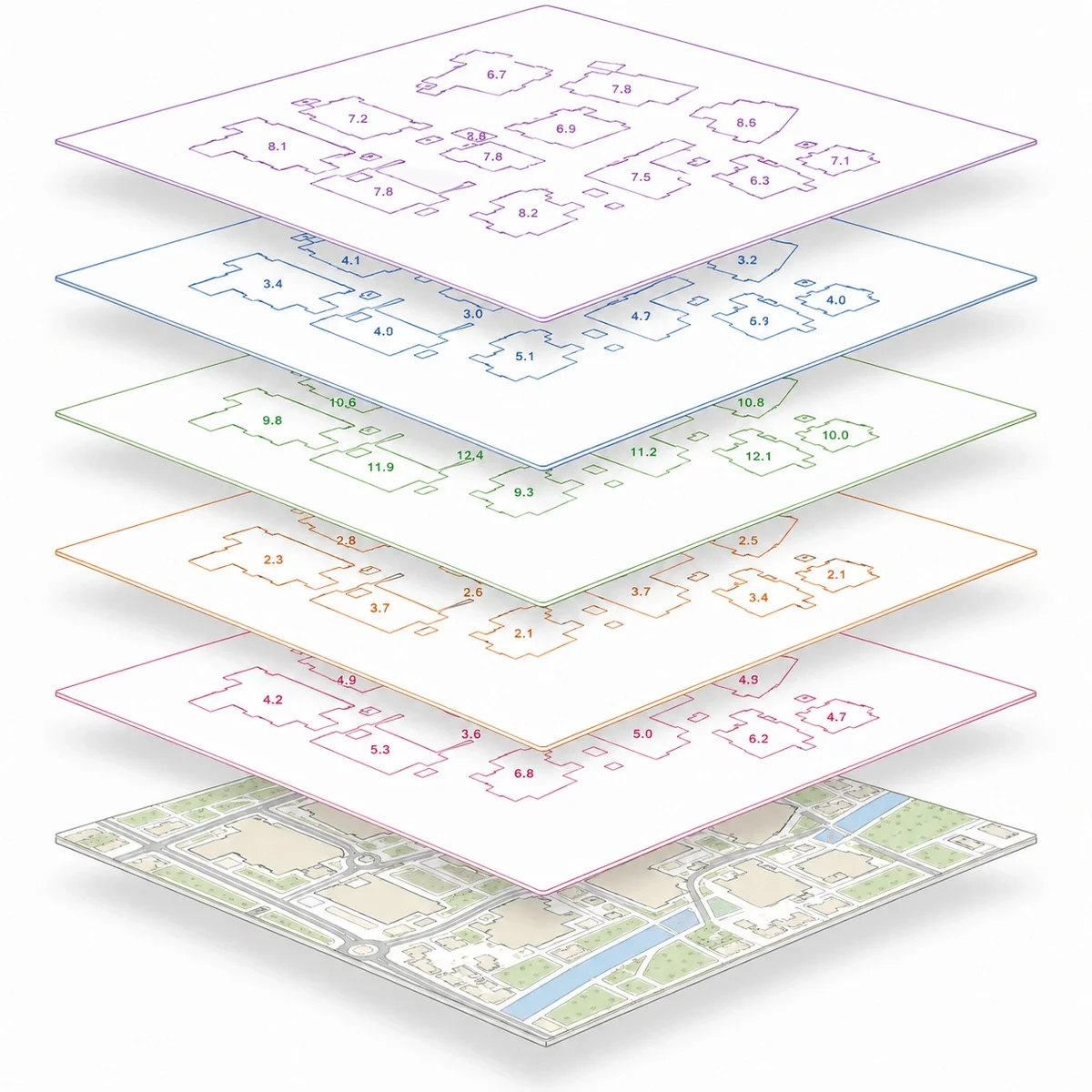
Building Heights are height attributes for buildings and selected structures within OS MasterMap® Topography Layer. They help architects, surveyors, planners, engineers and property professionals understand the height, scale and massing of buildings in a mapped area.
MapServe supplies Building Heights as an additional CAD layer with OS MasterMap®, available in DWG and DXF formats. The layer is useful for site analysis, planning context, visualising urban density, project planning, asset management and simple 3D building analysis.
Ordnance Survey describes Building Height Attribute as an enhancement to OS MasterMap Topography Layer, containing absolute and relative height values for buildings and selected structures. It includes buildings, tanks, industrial chimneys and glasshouses.

| Sector | Need | Why it's used | Typical format |
|---|---|---|---|
| Architecture | Understand surrounding building scale | Helps assess massing, overlooking, daylight context and design relationship with neighbouring buildings | DWG, DXF |
| Planning | Assess development impact | Supports early review of urban form, building scale, density and site context | DWG, DXF |
| Surveying | Add height context to CAD mapping | Provides a useful building height reference layer alongside OS MasterMap® | DWG, DXF |
| Engineering | Review structures and built-form constraints | Helps assess height-related constraints, clearance context and infrastructure planning | DWG, DXF |
| Telecoms | Support line-of-sight analysis | Building height information can assist early desktop checks for mast, rooftop and small-cell planning | DWG, DXF |
| Development | Early-stage feasibility | Helps assess site context, massing risk and surrounding building scale before detailed design | DWG, DXF |
| Map product | Best used for | Key limitations |
|---|---|---|
| Building Heights | Building height context in CAD with OS MasterMap® | Does not replace a measured survey or full 3D model |
| Measured building survey | Accurate site-specific building dimensions and levels | Requires survey work and is usually more expensive |
| Topographic survey | Visual context and roof interpretation | May not include full building height attributes unless specified |
| Aerial photography | Visual context and roof interpretation | Does not provide structured height attributes |
| 3D city model | Advanced visualisation and modelling | May be more complex than needed for simple CAD context |
Building Heights are useful for desktop assessment, planning context and CAD analysis, but they are not suitable for every height-related task.
| Attribute | Description |
|---|---|
| Coverage | Great Britain |
| Formats | CAD (DWG & DXF) |
| Options | Colour, black & white |
| Printable scales | 1:100 – 1:10,000 |
| Stated accuracy | Urban +/- 1m, rural +/- 2.5m, moorland / mountain +/- 8m |
| Updates | Every 6 months |
| Delivery | Within seconds of ordering |
| Licence options | 12 months (other options available on request) |
| Projection | OSGB36 geodetic datum using Transverse Mercator projection |
| Grid | British National Grid |
| Supplied with | OS MasterMap® |
| Content | Building height attributes for buildings and selected structures |
| Key attributes | AbsHMin, AbsH2, AbsHMax, RelH2, RelHMax |
| Included structures | Buildings, tanks, industrial chimneys and glasshouses |
| Source | OS MasterMap Topography Layer – Building Height Attribute |
| Source method | Photogrammetrically derived Digital Terrain Models and Digital Surface Models |
| Price | From £13.72 |
| Best used for | CAD, planning context, site analysis, asset management, urban density review and simple 3D building context |
Building Heights are height attributes for buildings and selected structures in OS MasterMap® Topography Layer. They help show the height, scale and built-form context of buildings across Great Britain.
Building Heights are available from MapServe from £13.72, when added to a map order.
MapServe supplies Building Heights as an additional CAD layer in DWG and DXF files.
It includes three absolute height values and two relative height values for buildings and selected structures. The main attributes are AbsHMin, AbsH2, AbsHMax, RelH2 and RelHMax.
Yes. Ordnance Survey describes Building Height Attribute as an enhancement to, and part of, OS MasterMap Topography Layer.
They are used for architectural context, planning analysis, urban density review, asset management, engineering checks, telecoms line-of-sight work and simple 3D visualisation.
Building Heights are not currently available as a live preview layer. You can preview OS MasterMap® before ordering.
Ordnance Survey states that the Building Height Attribute product is updated every six months, in April and October.
Building Heights are only available in CAD format (DWG or DXF format). If you do not have CAD software installed you can use this free online viewer.
DWG and DXF files require CAD software, such as AutoCAD or a compatible CAD viewer.


