Instant Download
Colour And Black & White Options
Save up to 40% vs. Other Suppliers


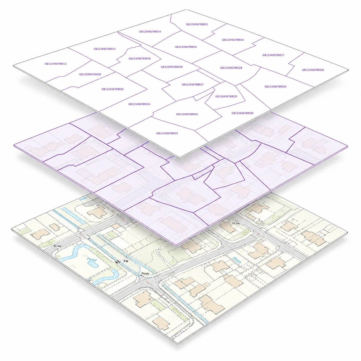
Freehold Boundaries show the indicative shape and position of registered freehold titles in England and Wales. They are supplied as a CAD layer alongside OS MasterMap®, helping architects, surveyors, planners and property professionals understand how registered land titles relate to real-world site features.
The layer is based on HM Land Registry INSPIRE Index Polygons. Each polygon represents the position and indicative extent of a registered freehold property and includes a Land Registry-INSPIRE ID that relates to a registered title.
Freehold Boundaries are useful for site analysis, land referencing, feasibility checks and understanding title context, but they should not be treated as the exact legal boundary of a property.

| Sector | Need | Why it's used | Typical format |
|---|---|---|---|
| Architecture | Understand title context around a site | Helps compare registered title polygons with buildings, roads, access and surrounding features | DWG, DXF |
| Surveying | Support land and boundary investigations | Provides title polygon context alongside OS MasterMap® and measured survey information | DWG, DXF |
| Planning | Check land ownership context for applications | Helps identify whether a proposal may affect neighbouring registered titles | DWG, DXF |
| Development | Early-stage site feasibility | Helps assess registered title patterns before further legal or title due diligence | DWG, DXF |
| Telecoms & infrastructure | Route and site planning | Supports early checks around land parcels, access routes and affected registered titles | DWG, DXF |
| Map product | Best used for | Key limitations |
|---|---|---|
| Freehold Boundaries layer | Indicative registered title context in CAD | Not a legal boundary determination |
| HM Land Registry title plan | Reviewing the registered title plan | Usually shows general boundaries, not exact surveyed boundaries |
| Measured/topographic survey | Accurate physical features on site | Does not confirm legal ownership |
| Boundary survey/legal advice | Disputes or exact boundary questions | Requires specialist evidence and professional advice |
Freehold Boundaries are useful for professional site context, but they are not suitable for every boundary-related task.
| Attribute | Description |
|---|---|
| Coverage | England & Wales |
| Formats | CAD (DWG & DXF) |
| Options | Colour, black & white |
| Printable scales | 1:200 – 1:10,000 |
| Updates | Monthly |
| Delivery | Within seconds of ordering |
| Licence options | 12 months (other options available on request) |
| Projection | OSGB36 geodetic datum using Transverse Mercator projection |
| Grid | British National Grid |
| Supplied with | OS MasterMap® |
| Content | Freehold registered title polygons |
| Identifier | Land Registry-INSPIRE ID |
| Source | HM Land Registry INSPIRE Index Polygons |
| Best used for | CAD, site analysis, planning context, land referencing and feasibility checks |
Freehold Boundaries show the indicative shape and position of registered freehold titles in England and Wales. They are supplied by MapServe as a CAD layer alongside OS MasterMap®.
No. Freehold Boundaries show indicative registered title polygons. They should not be treated as exact legal boundary lines.
The layer is based on HM Land Registry INSPIRE Index Polygons, which contain the locations of freehold registered property in England and Wales.
A Land Registry-INSPIRE ID is a unique identifier attached to an INSPIRE Index Polygon. HM Land Registry states that the ID relates to a registered title.
Yes. HM Land Registry states that an INSPIRE ID can be used with its Find a Property service to get the title registration and plan for each polygon.
Freehold Boundaries are available from MapServe in CAD formats: DWG and DXF.
Freehold Boundaries are not currently available as a live preview layer. Sample files are available so you can see how the layer appears in CAD.
They can help provide ownership and title context for planning work, but they do not replace official title documents, planning drawings, measured surveys or legal boundary advice.
No. This layer covers England and Wales.
Do not use them to determine an exact legal boundary, resolve a boundary dispute, replace a title plan, or substitute for a measured survey.


