Free to view MasterMap®
Download in a few minutes
Save up to 40% vs. other suppliers


MapServe and Promap both supply professional mapping for architects, surveyors, planners, engineers and property professionals. Both services provide access to OS MasterMap®, the detailed Ordnance Survey mapping product widely used for CAD, planning and site analysis.
This page compares MapServe with Promap on the things that matter when ordering professional mapping: price, previews, formats, CAD options, optional data layers, usability and workflow tools.
MapServe is designed for users who want fast online ordering, clear previews, competitive pricing and optional extras that add deeper site context before design, planning or survey work begins.

| Sector | Need | Why it's used | Typical format |
|---|---|---|---|
| Architecture | CAD base plans and planning drawings | Download OS MasterMap® with optional contours, boundaries, trees and building heights | DWG, DXF, PDF |
| Surveying | Accurate site context | Use OS MasterMap® and optional layers as a desktop reference before or alongside survey work | DWG, DXF |
| Planning | Planning maps and site analysis | Create planning context maps with additional constraints and site insight | PDF, DWG, DXF |
| Development | Early feasibility | Understand site layout, landform, ownership context, trees and surrounding buildings | DWG, DXF, PDF |
| Telecoms | Desktop site checks | Use building heights, MasterMap® and site context for early feasibility and access checks | DWG, DXF |
| Map product | Best used for | Key limitations |
|---|---|---|
| Price | Mapping costs add up for repeat professional users | MapServe highlights savings of up to 40% vs Promap |
| Previewing | Users often need to check a map before buying | MapServe offers free OS MasterMap® previews |
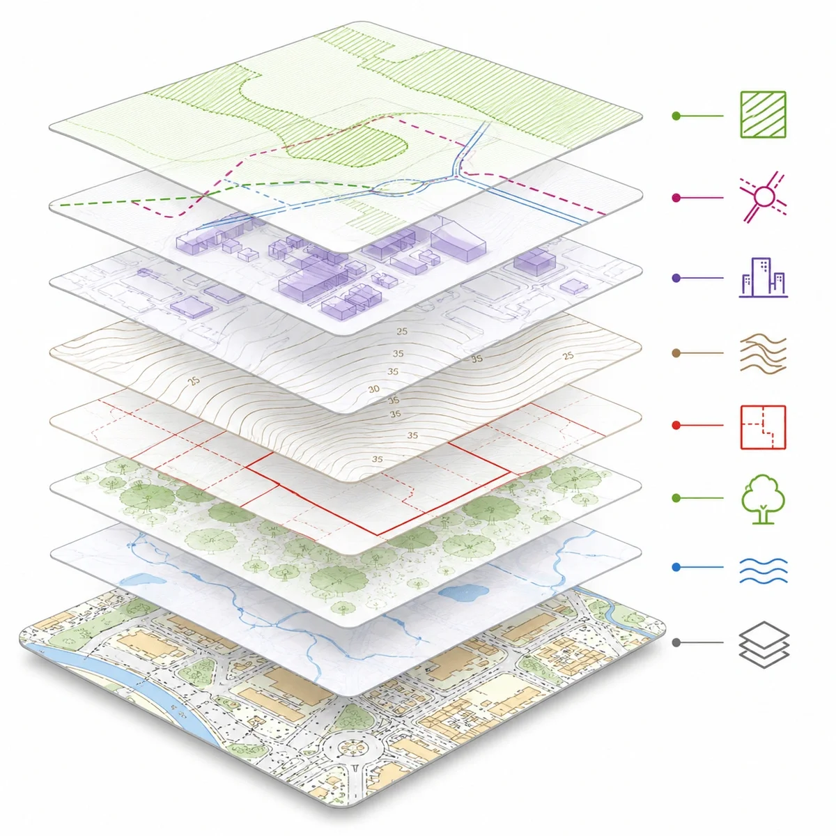
| Optional extras | Site context often needs more than base mapping | MapServe offers contours, boundaries, tree data, building heights and more |
| CAD workflow | Architects and surveyors need usable CAD output | MapServe supports DWG and DXF downloads |
| Area selection | Professional sites are rarely simple rectangles | MapServe includes rectangle, polygon, auto outline, snap-to-point and saved area tools |
| Speed | Professionals often need mapping immediately | MapServe is designed for fast preview and download |
MapServe is designed for fast professional mapping orders, especially where you need OS MasterMap®, CAD formats and optional site insight layers. It may not be the best fit in every case.
Use another service or specialist supplier where you need:
MapServe is best used for fast access to professional mapping and optional data layers, not as a replacement for specialist legal, planning, surveying or engineering advice.
| Attribute | Description |
|---|---|
| Page purpose | Compare MapServe with Promap for professional mapping |
| Primary audience | Architects, surveyors, planners, engineers, developers and land/property professionals |
| Main product focus | OS MasterMap® and professional CAD mapping |
| MapServe formats | DWG, DXF, PDF, PNG, GML |
| Main MapServe optional layers | 1m contours, freehold boundaries, building heights, National Tree Map™, 3D MasterMap® |
| Price message | Save up to 22.4% vs Promap |
| Preview message | Free OS MasterMap® previews |
| Key workflow tools | Auto outline, rectangle, polygon, snap-to-point, paper size, saved areas |
| Best used for | Comparing mapping suppliers before ordering professional mapping |
MapServe currently highlights savings of up to 40% vs Promap on OS MasterMap®. Pricing should always be checked at the point of order because mapping costs can vary by area, format, licence and selected options.
Yes. MapServe supplies OS MasterMap® in professional formats including CAD, PDF, PNG and GML.
Yes. MapServe allows users to preview OS MasterMap® before ordering, so you can check the map area before downloading.
Yes. Promap supplies OS MasterMap® and lists formats including DWG, DXF, DGN, JPG, PNG and PDF on its OS MasterMap® page.
MapServe focuses on fast online ordering, free MasterMap® previews, competitive pricing and optional layers such as 1m contours, freehold boundaries, building heights, National Tree Map™ and 3D MasterMap®.
Yes. MapServe supports CAD mapping in DWG and DXF formats.
MapServe is used by architects, surveyors, planners, engineers, developers and other land and property professionals.
Yes. MapServe offers optional extras including 1m contours and freehold boundaries, alongside other layers such as building heights and National Tree Map™.
No. This is a MapServe comparison page. It is intended to explain how MapServe compares with Promap from MapServe’s perspective. Users should check both suppliers directly before ordering.


