When assessing a site for development, extension or planning potential, most professionals expect planning constraints to be relatively straightforward to identify.
Flood zones can often be checked nationally. Listed buildings are widely available. Conservation Areas are increasingly accessible through mapping platforms.
Tree Preservation Orders (TPOs) are different.
Across the UK, TPO information is often fragmented, inconsistent and difficult to access. Some councils provide excellent interactive mapping systems, while others rely on PDFs, scanned documents or registers that can be difficult to interpret.
For architects, planning consultants, surveyors and developers, this creates unnecessary delays during site appraisal and feasibility assessments.
The challenge is not understanding the importance of protected trees.
The challenge is finding reliable Tree Preservation Order information quickly enough to influence project decisions.
The UK's Fragmented TPO Landscape
Tree Preservation Orders are made by local planning authorities to protect trees that provide significant public amenity value.
While the legislation is national, the way TPO information is managed and published is largely local.
This means there is no single national system for carrying out a Tree Preservation Order search.
Instead, professionals often need to investigate individual local authority records, websites and mapping systems to determine whether a site may be affected.
For organisations working across multiple regions, this can create a significant administrative burden.
A planning consultant assessing sites in three neighbouring authorities may encounter three completely different systems for accessing the same type of information.
In some cases, identifying TPO constraints can take longer than checking multiple other planning constraints combined.
Why Every Council Publishes Data Differently
One of the biggest challenges with TPO searches is inconsistency.
Depending on the authority, Tree Preservation Orders may be published as:
- Interactive GIS maps
- PDF maps
- Scanned paper records
- TPO registers
- Planning constraint layers
- Downloadable datasets
- Individual order documents
- Information available only on request
Even where mapping exists, the quality and usability can vary significantly.
Common issues include:
Different Mapping Systems
Every authority may use a different mapping platform, interface and search process.
Users must continually learn new workflows when checking sites across multiple council areas.
Different Data Structures
Some councils map individual trees.
Others map groups of trees.
Some use woodland polygons.
Others provide only reference numbers linked to separate documents.
Different Update Processes
Not all authorities update their public records in the same way or at the same frequency.
This can make it difficult to understand the completeness of available information.
Different Levels of Accessibility
Some authorities make TPO information easy to locate.
Others require multiple searches through planning portals, document libraries or GIS systems before information can be found.
For professionals conducting multiple site assessments each week, these differences quickly add up.

The Hidden Cost for Architects and Developers
Many teams underestimate the impact of delayed TPO identification.
Discovering protected trees late in the planning process can have significant consequences.
Design Revisions
Protected trees can influence:
- Building footprints
- Extensions
- Site layouts
- Access arrangements
- Parking layouts
- Landscaping proposals
If a TPO is identified after concept design work has been completed, redesign may become necessary.
Delays During Feasibility
Land buyers and developers often need rapid constraint screening before progressing opportunities.
If multiple council systems must be checked individually, site assessments become slower and less scalable.
Increased Consultant Time
Planning consultants and architects frequently spend valuable project time gathering information rather than analysing it.
The cost is not simply the time spent searching.
It is the opportunity cost of delayed decision-making.
Planning Risk
One of the most common feasibility mistakes is assuming tree constraints can be checked later.
By the time a planning application is being prepared, protected trees may already be influencing fundamental design decisions.
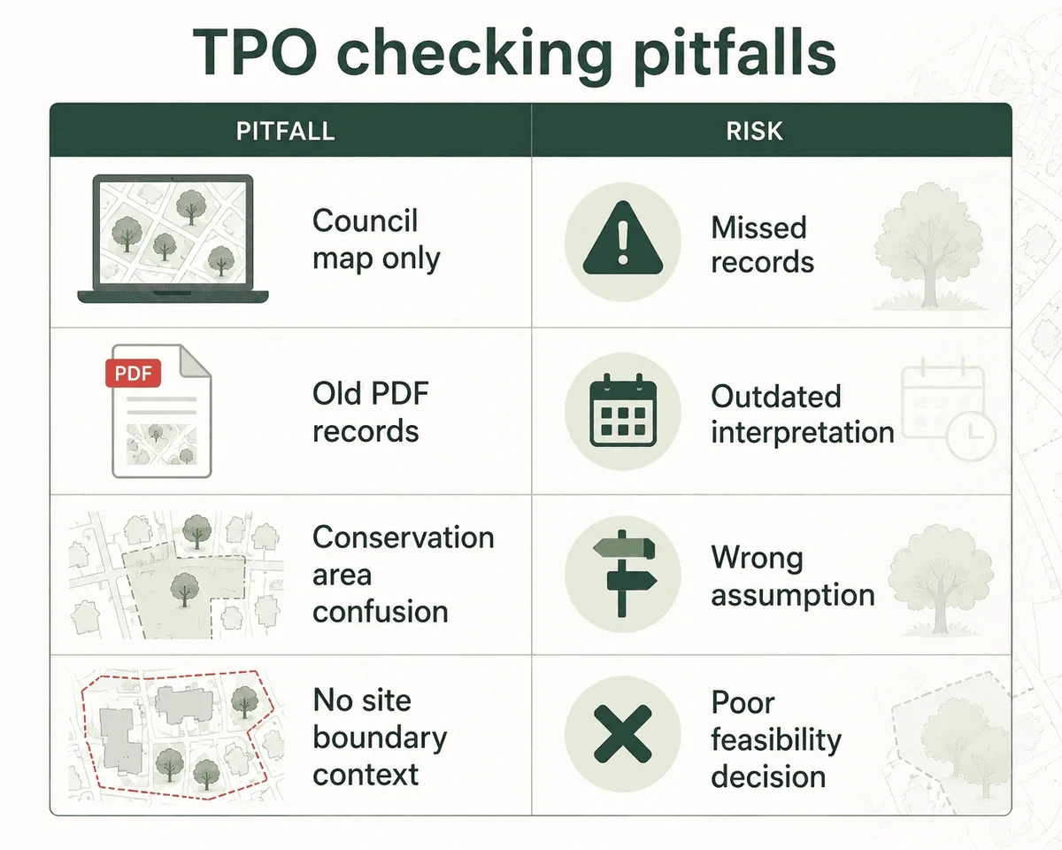
Common Mistakes When Checking TPOs
Even experienced professionals can encounter problems when carrying out Tree Preservation Order searches.
Assuming All Trees Are Protected
Many planning professionals mistakenly assume that the presence of trees automatically indicates legal protection.
In reality, a site may contain significant tree cover without any Tree Preservation Orders, while a single protected tree may have a substantial impact on development proposals.
Using tree mapping alongside Tree Preservation Order data provides a more complete understanding of site constraints.
Assuming Trees Are Not Protected
A tree does not need to appear obviously significant to be protected.
Many TPOs apply to groups of trees, woodlands or areas rather than individual specimens.
Checking Only One Source
Relying solely on planning application records or aerial imagery may not reveal the presence of a Tree Preservation Order.
Confusing TPOs with Conservation Areas
Many trees within Conservation Areas receive separate protections.
The two constraints are related but not identical.
Understanding the distinction is important when assessing development potential.
Leaving Tree Checks Until Late in the Process
Perhaps the most expensive mistake is treating TPO checks as a validation-stage task rather than a feasibility-stage task.
By that point, important design decisions may already have been made.
Failing to Consider Wider Planning Constraints
Trees rarely exist in isolation.
Sites affected by TPOs may also be influenced by:
- Conservation Areas
- Listed Buildings
- Article 4 Directions
- Flood Risk
- Green Belt constraints
Understanding these layers together provides a far more accurate picture of planning risk.
How Centralised TPO Mapping Changes Feasibility Workflows
Modern planning workflows increasingly depend on fast access to reliable spatial data.
Rather than searching multiple council systems individually, planners and developers are increasingly looking for centralised approaches to constraint screening.
A centralised TPO mapping workflow can help:
Speed Up Site Assessments
Users can review potential tree constraints in seconds rather than searching multiple websites.
Improve Consistency
The same workflow can be used regardless of location.
Support Earlier Decision-Making
Potential constraints can be identified before significant design or acquisition costs are incurred.
Reduce Planning Risk
Understanding tree constraints early helps avoid avoidable redesigns and delays.
Enable Scalable Site Screening
For organisations reviewing multiple sites, consistent access to planning intelligence improves efficiency and confidence.
The goal is not simply to find protected trees faster.
The goal is to make better planning decisions earlier.
Introducing the MapServe Tree Preservation Order Map
The new MapServe Tree Preservation Order Map has been designed to address one of the most fragmented planning datasets in the UK.
Instead of searching multiple local authority systems individually, users can access Tree Preservation Order information through a single mapping platform.
The service supports architects, planning consultants, developers, surveyors and land professionals who need to understand potential constraints before progressing projects.
Key benefits include:
- Faster Tree Preservation Order searches
- Consistent mapping workflows
- Improved site feasibility assessments
- Earlier identification of planning constraints
- Reduced risk of costly redesigns
- Better-informed land acquisition decisions
Most professionals already understand that trees matter.
The real challenge is accessing reliable information quickly enough to influence planning, design and investment decisions.
As planning workflows become increasingly data-driven, centralised access to Tree Preservation Order information has become a valuable part of modern planning intelligence.
Frequently Asked Questions
What is a Tree Preservation Order?
A Tree Preservation Order is a legal protection made by a local planning authority to safeguard trees that provide public amenity value.
How do I carry out a Tree Preservation Order search?
Traditionally, searches are completed through local authority mapping systems, registers or planning portals. However, availability and format vary between councils.
Is there a national TPO map for the UK?
There is no single official national system that provides Tree Preservation Order information in a consistent format across all local authorities.
Why is TPO data difficult to access?
TPO records are typically managed locally, resulting in different publication methods, formats and levels of accessibility.
Why should TPOs be checked during feasibility?
Identifying protected trees early can reduce planning risk, avoid redesign costs and improve site acquisition decisions.