Tree Preservation Orders can have a major impact on site design, planning risk and tree work permissions. For architects, planning consultants, surveyors and developers, checking whether a site is affected by a TPO should be an early part of feasibility work, not a last-minute validation check.
A Tree Preservation Order, usually shortened to TPO, is made by a local planning authority to protect specific trees, groups of trees or woodland. Government planning guidance explains that protected trees cannot normally be cut down, uprooted, topped, lopped, wilfully damaged or destroyed without consent. The Planning Data service also defines TPO data as information used by developers, applicants and the public to check whether trees are protected and to inform planning applications or tree work proposals.
For project teams, the practical problem is not simply understanding what a TPO is. It is finding out, quickly and reliably, whether one affects a site.
Why TPO checks matter early
A TPO constraint can affect:
- site layout
- access routes
- proposed extensions
- demolition sequencing
- arboricultural survey requirements
- planning application strategy
- construction method statements
- root protection areas
- landscaping proposals
- buildability and redesign risk
Many teams only check tree constraints after a site plan has already been drafted. That creates avoidable risk. If a protected tree sits close to a proposed access route, building line or service trench, the design may need to be amended. In some cases, a late TPO discovery can trigger new surveys, revised drawings and additional planning justification.
A better workflow is to screen the site at the same time as other planning constraints, including flood risk, conservation areas, listed buildings, Article 4 Directions and green belt where relevant. MapServe’s planning constraints map helps project teams review these risks together before design decisions are locked in.
How to check whether a tree has a TPO
There are several ways to check TPOs, but they vary in speed, coverage and usability. A dedicated Tree Preservation Order map helps you check protected tree constraints in relation to the site boundary, nearby buildings, access routes and wider planning constraints.
1. Check the local authority website
Most TPO records are held by local planning authorities. Some councils provide interactive maps, while others publish lists, PDFs, GIS layers or planning portal records.
This can be useful for single-site checks, but it becomes inefficient when:
- the project crosses administrative boundaries
- the council map is hard to use
- TPO records are in PDFs rather than spatial layers
- you need the information in CAD or GIS workflows
- you are comparing several sites at feasibility stage
Council data can also vary in format. One authority may show individual trees, while another may show groups, areas or woodland orders.
2. Search the planning portal
Planning portals can help identify historic applications, tree works applications and conditions. However, they are not always the fastest way to understand whether a tree constraint affects a red line boundary.
A planning portal search may tell you that a tree works application exists, but it may not provide a clean spatial overlay for early design work.
3. Use a TPO map
A dedicated TPO map is often the most practical option for professionals who need to understand tree constraints in a spatial context.
With MapServe’s Tree Preservation Order map, project teams can check TPO constraints alongside professional mapping and wider planning intelligence. This is especially useful when the question is not just “is there a TPO?” but “where is the protected tree in relation to the site, access, boundary, buildings and neighbouring constraints?”
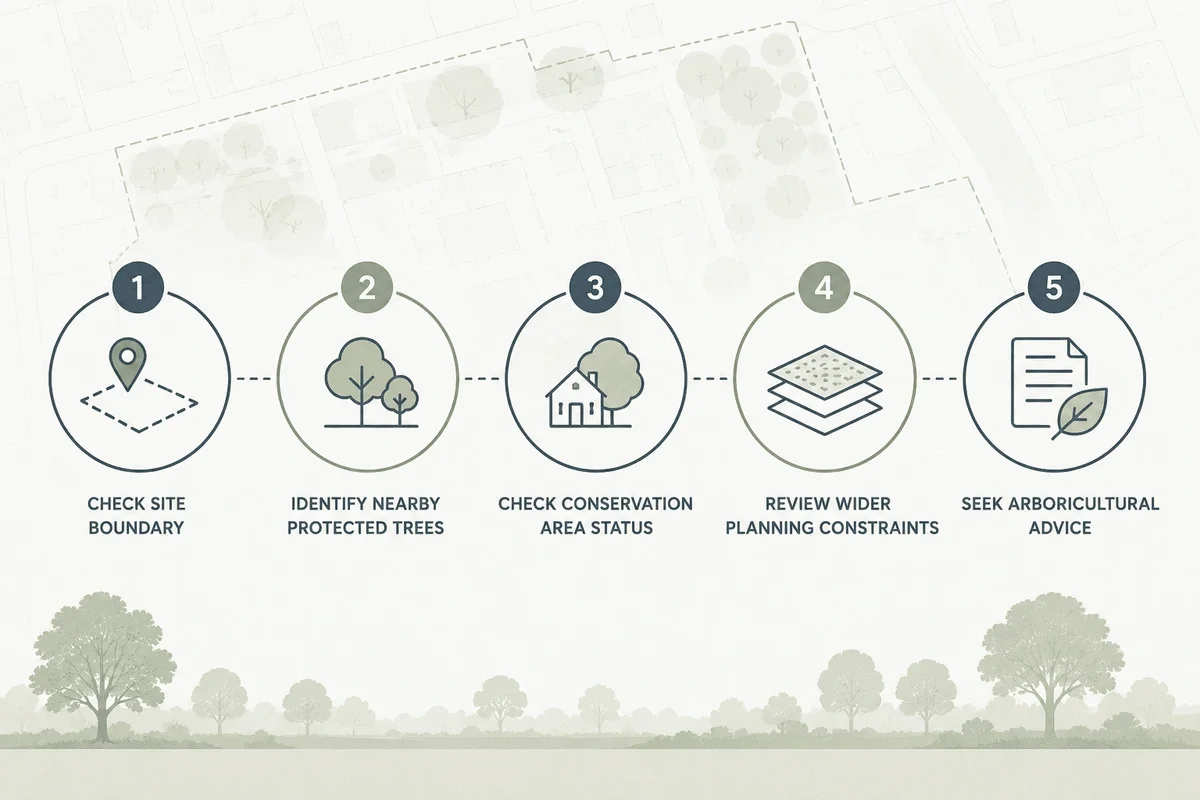
What to look for during a TPO check
A useful TPO review should answer five questions.
1. Is the site affected by a TPO?
Start by checking whether the site itself contains protected trees, groups, areas or woodland. Do not rely only on visible trees within the red line boundary. Nearby trees can still influence design if their canopy or root protection area extends into the working area.
2. Are there protected trees near the boundary?
Trees outside the site can still affect development. The National Tree Map™ can add useful context by showing tree location, height and canopy coverage around the site.
A neighbouring protected tree may influence excavation, foundations, access, drainage or construction methodology.
This is where a map-based view is more useful than a text-only record. Seeing the constraint in relation to OS MasterMap, site boundaries and nearby features helps the design team understand whether the issue is likely to be material.
3. Is the site also in a conservation area?
TPOs are not the only tree-related planning constraint. Trees in conservation areas are also subject to controls. Government guidance states that unauthorised works to trees in conservation areas can be an offence unless exceptions apply.
This matters because a site may have no TPO but still require notice before tree works if it lies in a conservation area.
4. Is an arboricultural survey needed?
A TPO map is a screening tool. It does not replace a site inspection or BS5837 arboricultural survey where one is required. However, it helps identify the need for specialist input earlier.
That early signal can save time. Instead of discovering the issue after drawings are prepared, the project team can bring in an arboricultural consultant while the layout is still flexible.
5. Could the TPO affect planning validation?
Planning authorities may request tree information where protected trees or relevant tree constraints affect the site. A missed TPO can result in further information requests, validation delays or design revisions.
For architects and planning consultants, the commercial value of an early TPO check is simple: fewer surprises, cleaner submissions and less redesign.
Why TPO data can be difficult to work with
TPO data is improving, but it remains fragmented. The national Planning Data service has a Tree Preservation Order dataset and a Tree Preservation Zone dataset, but it also warns that some planning data may be incomplete and that availability is still being improved.
In practice, this means professionals should treat TPO checks as part of a wider due diligence workflow, rather than a single yes/no lookup.
Common issues include:
- inconsistent local authority formats
- older paper-based orders
- partial digitisation
- group or area orders that need interpretation
- unclear relationship between mapped data and legal order documents
- lack of CAD-ready outputs
This is one reason MapServe positions TPO checking as part of mapping + planning intelligence, rather than as an isolated dataset.
A better TPO workflow for planning teams
For early-stage site assessment, use the following workflow:
- Start with accurate base mapping.
- Add the site boundary or area of interest.
- Check TPO constraints.
- Check conservation areas and other planning constraints.
- Review nearby trees and boundary relationships.
- Decide whether arboricultural input is required.
- Keep a record of the constraint check for the project file.
This approach is particularly useful for small residential schemes, extensions, infill development, land promotion, site appraisals and pre-application advice.
Where MapServe fits in
MapServe helps professionals check tree and planning constraints in a spatial workflow.
The Tree Preservation Order map helps users identify protected tree constraints and understand how they relate to the site. The National Tree Map can add tree location, height and canopy context, while wider planning constraints maps can show other risks such as flood zones, listed buildings, conservation areas and Article 4 Directions.
The result is a clearer early-stage view of planning risk.
Key takeaway
Do not leave TPO checks until after the design has been drafted.
A fast TPO review can help identify protected trees, reduce redesign risk, support planning due diligence and highlight when arboricultural input may be needed.
For architects, planners, surveyors and developers, the safest workflow is to check TPOs alongside other site constraints before committing to a layout.
Check your site with MapServe’s Tree Preservation Order map
FAQs
What is a Tree Preservation Order?
A Tree Preservation Order is a legal order made by a local planning authority to protect specific trees, groups of trees or woodland.
How do I check if a tree has a TPO?
You can check local authority records, planning portals or use a dedicated TPO map to view protected tree constraints spatially.
Can I cut back a tree with a TPO?
You normally need consent from the local planning authority before cutting down, topping, lopping, uprooting, damaging or destroying a protected tree.
Is a TPO map the same as an arboricultural survey?
No. A TPO map is useful for screening and feasibility. It does not replace a site inspection or professional arboricultural survey where one is required.
Can trees in conservation areas be protected even without a TPO?
Yes. Trees in conservation areas are subject to separate controls, so conservation area checks should be part of early planning due diligence.