
Do You Need a Survey or OS Mapping?
A topographic site plan can be essential for detailed design, but not every early-stage project needs a full measured survey immediately. For architects, planners and developers, the challenge is knowing what level of information is needed at each stage.
OS mapping, contours and building height data can often support early feasibility work before a full topographical survey is commissioned.
This guide explains the difference between topographic site plans, OS mapping and measured surveys, and how to choose the right starting point.
What Is a Topographic Site Plan?
A topographic site plan shows physical features and level information across a site. It may include:
- ground levels
- buildings
- walls and fences
- trees
- roads and kerbs
- drainage features
- paths
- slopes
- boundaries
- service covers
- surrounding features
A full topographical survey is usually measured on site by a surveyor. It provides detail needed for design, engineering and construction.
What OS Mapping Provides
OS mapping provides mapped context rather than a full measured site survey. It can show buildings, roads, paths, boundaries and surrounding features.
When combined with additional datasets, it can also support early analysis of:
- contours
- approximate level changes
- building heights
- ownership context
- tree cover
- urban form
This makes it valuable for feasibility and planning context.
Topographic Site Plan vs OS Map
The two are not interchangeable.
OS Mapping Is Useful For:
- site context
- planning location plans
- feasibility studies
- early access reviews
- surrounding building context
- drawing preparation
- initial constraints mapping
A Topographical Survey Is Needed For:
- detailed design
- drainage design
- construction drawings
- precise level changes
- boundary and feature measurement
- engineering coordination
- complex sites
The right choice depends on risk, project stage and required accuracy.
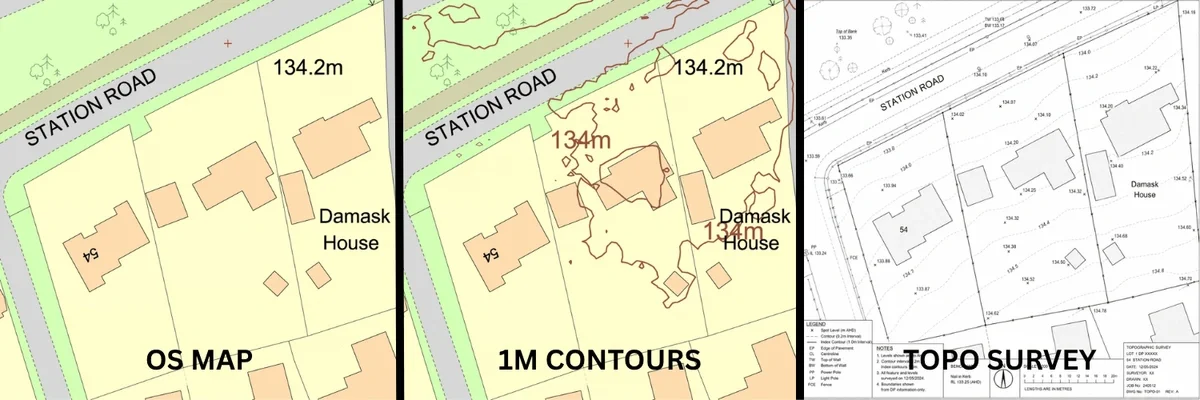
When OS Mapping May Be Enough
OS mapping may be suitable when the project is at early stage and the team needs to understand general context rather than precise measurements.
Examples include:
- initial development appraisal
- planning pre-application work
- site location plans
- early massing studies
- access feasibility
- land promotion
- client feasibility reports
- surrounding context analysis
At this stage, editable CAD site plans can also help teams turn OS mapping into early feasibility and planning drawings.
At this stage, the aim is often to decide whether a project is viable before commissioning more detailed surveys.
When You Should Commission a Topographical Survey
A measured topographical survey is likely needed when:
- ground levels affect the design
- drainage strategy depends on levels
- construction detail is required
- site features need precise location
- existing structures are being retained
- access gradients matter
- legal or boundary precision is important
- the site is constrained or complex
If design decisions rely on accurate measured information, a topo survey is the safer option.
How Contours Help Early Design
Contour mapping can help architects understand slope and level changes before commissioning a full survey.
This is useful for:
- assessing buildability
- comparing development options
- reviewing access constraints
- understanding visual impact
- preparing early site analysis
- identifying where level issues may arise
Contours are not a substitute for a measured survey, but they can help identify risks early.
How Building Heights Support Site Analysis
Building height data can be useful in urban contexts where surrounding scale matters.
Architects and planners may use it to assess:
- neighbouring massing
- townscape context
- overlooking concerns
- skyline impact
- development capacity
- site constraints
For early design, building height data can provide useful context before more detailed modelling is carried out.
A Sensible Project Workflow
A practical approach is:
- Use OS mapping for site context.
- Add contours or building height data where useful.
- Prepare feasibility drawings.
- Identify key risks.
- Commission a measured survey when the project moves into detailed design.
This gives design teams a practical mapping for architects workflow: start with context, identify risks, then commission measured survey data when accuracy becomes critical.
This helps avoid commissioning detailed surveys too early while still supporting informed decisions.
Conclusion
A topographic site plan and OS mapping serve different purposes. OS mapping is often enough for early feasibility and planning context, while measured topographical surveys are essential for detailed design.
The best approach is to match the mapping product to the project stage.
Need early-stage site context? Explore MapServe’s topographical maps, contours and related mapping datasets.
FAQs
Is OS mapping the same as a topographical survey?
No. OS mapping provides mapped context, while a topographical survey provides measured site detail.
Can contours replace a topo survey?
No, but they can support early feasibility and site analysis.
When do I need a measured survey?
You need one when precise levels, features or construction information are required.
Are topographic site plans useful for planning?
Yes, especially where levels, access or site constraints matter.
Can building height data help architects?
Yes. It can support early massing, townscape and context analysis.