
Getting the correct site plan scale is one of the most overlooked, but critical, parts of a planning application.
It’s not just a technical detail.
It directly affects whether your application is validated or rejected.
In this guide, we’ll break down exactly what scale you need, when to use it, and how to avoid the common mistakes that delay approvals.
What Is a Site Plan Scale?
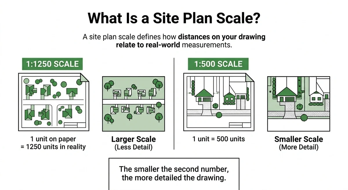
A site plan scale defines how distances on your drawing relate to real-world measurements.
For example:
-
1:1250 → 1 unit on paper = 1250 units in reality
-
1:500 → 1 unit = 500 units
The smaller the second number, the more detailed the drawing.
UK Standard Site Plan Scales
1:1250 – The Default Planning Scale
This is the most commonly accepted scale for planning applications.
Use it when:
-
Showing the site in a wider context
-
Identifying surrounding roads and properties
-
Submitting location plans
However, this scale often lacks detail for smaller or complex sites.
1:500 – The Practical Working Scale
This is where most site plans should sit.
Use it when:
-
Showing boundaries clearly
-
Including access points and parking
-
Highlighting neighbouring structures
Local authorities frequently expect this level of detail, even if they don’t explicitly say so.
1:200 – High Detail (Urban / Tight Sites)
Required when:
-
Sites are constrained
-
Boundary clarity is critical
-
Multiple structures exist
This is especially common in dense urban environments.
Why Scale Errors Cause Planning Rejection
Planning officers don’t just glance at your drawings, they validate them.
Common rejection triggers:
-
Missing scale bar
-
Incorrect scale label
-
Distorted PDF output
-
Inconsistent scaling between drawings
Even a perfectly designed scheme can be rejected at this stage.
The CAD Export Problem (And How to Avoid It)
One of the biggest hidden issues is scale distortion during export.
What goes wrong:
-
“Fit to page” settings alter scale
-
Paper size mismatch
-
PDF viewers auto-resizing
How to fix it:
-
Always export at 100% scale
-
Include a scale bar
-
Test print a sample
This step alone prevents a huge number of validation failures.
Scale Bar vs Ratio: What Planning Officers Actually Check
Many applicants assume writing “Scale 1:500” is enough.
It isn’t.
Most councils expect:
-
A visual scale bar
-
Clearly labelled measurements
-
Consistency across all drawings
Without this, your plan may be deemed invalid.
Choosing the Right Scale for Your Project
Here’s a simple rule:
|
Project Type |
Recommended Scale |
|
Rural / large plot |
1:1250 |
|
Standard residential |
1:500 |
|
Dense urban |
1:200 |
If in doubt, always choose more detail over less.
How Site Plan Scale Links to Other Planning Drawings
Your site plan doesn’t exist in isolation.
It must align with:
-
Elevation drawings
Mismatch between these is a common validation issue.
Best Practice Checklist
Before submitting your site plan:
✅ Correct scale selected
✅ Scale bar included
✅ Boundaries clearly marked
✅ PDF exported at true scale
✅ Matches other submitted drawings
When to Use Professional Mapping Data
If you’re sourcing mapping:
-
Ensure it supports accurate scaling
-
Avoid low-resolution or raster-only plans
-
Use vector-based mapping where possible
This ensures consistency from CAD to submission.
FAQs
What scale should a site plan be in the UK?
Typically 1:500 or 1:1250, depending on detail required.
Is 1:1250 always acceptable?
No. Smaller or complex sites often require 1:500 or 1:200.
Do I need a scale bar?
Yes. Most councils require a visual scale bar.
Can I resize a site plan PDF?
No. Resizing invalidates the scale.
What happens if the scale is wrong?
Your application may be rejected at validation stage.