
When checking a site for planning risk, one of the first questions is whether the land falls within Flood Zone 2 or Flood Zone 3.
For architects, planning consultants, developers and surveyors, the difference matters. Flood Zone 2 and Flood Zone 3 both relate to flood risk from rivers and the sea, but they do not carry the same level of planning risk.
The zone a site falls into can influence whether a Flood Risk Assessment is needed, how a layout is designed, whether the Environment Agency may be consulted and how much early-stage due diligence is required.
A site being in Flood Zone 2 or 3 does not automatically mean it cannot be developed. However, it does mean the project team should understand the constraint before committing to a planning strategy, site layout or land purchase.
This guide explains the difference between Flood Zone 2 and Flood Zone 3, what each means for planning applications and why site-specific flood risk mapping is useful during early feasibility.
Quick answer: Flood Zone 2 vs Flood Zone 3
Flood Zone 2 indicates a medium probability of flooding from rivers or the sea.
Flood Zone 3 indicates a higher probability of flooding from rivers or the sea.
For planning purposes, Flood Zone 3 is usually more significant because it represents a higher level of flood probability and is more likely to affect application requirements, development layout, mitigation and consultation.
|
Factor |
Flood Zone 2 | Flood Zone 3 |
|---|---|---|
| General risk level | Medium probability | Higher probability |
| Flood source | Rivers and the sea | Rivers and the sea |
| Planning impact | May require flood risk evidence | More likely to require detailed flood risk evidence |
| Layout impact | May affect site layout and access | More likely to affect layout, levels and mitigation |
| Application risk | Moderate | Higher |
| Common next step | Early flood zone check | Flood Risk Assessment and planning strategy review |
Flood Zones 2 and 3 are not the same as surface water flood risk. This article focuses on flood risk from rivers and the sea only. Surface water flood risk should be assessed separately where relevant.
What is Flood Zone 2?
Flood Zone 2 is land assessed as having a medium probability of flooding from rivers or the sea.
In practical terms, Flood Zone 2 is a warning flag for planning. It tells the project team that flood risk may need to be considered before the application is submitted.
A site in Flood Zone 2 may still be suitable for development, but the team should check:
- whether the proposed building footprint is affected
- whether access routes cross the flood zone
- whether the development type is vulnerable to flooding
- whether a Flood Risk Assessment is required
- whether the Sequential Test is relevant
- whether the Local Planning Authority has specific flood risk policies
- whether climate change allowances need to be considered
Flood Zone 2 should not be dismissed as a minor issue. It may be less severe than Flood Zone 3, but it can still affect planning evidence, consultant input, layout decisions and programme risk.
What is Flood Zone 3?
Flood Zone 3 is land assessed as having a higher probability of flooding from rivers or the sea.
For planning teams, this usually requires more careful attention than Flood Zone 2. A site in Flood Zone 3 is more likely to need flood risk evidence, design mitigation and a clear planning justification.
Flood Zone 3 may affect:
- whether the development is acceptable in principle
- whether a Flood Risk Assessment is required
- whether the Sequential Test or Exception Test applies
- whether finished floor levels need to be raised
- whether safe access and escape can be demonstrated
- whether buildings should be moved to a lower-risk part of the site
- whether certain uses are unsuitable
- whether the Environment Agency may object without further evidence
Flood Zone 3 does not automatically rule out development. Some schemes can still proceed, especially where the proposal is appropriate for the level of risk and suitable mitigation can be demonstrated. However, it should be treated as a material planning constraint from the start of the project.
Why Flood Zone 3 is usually more important for planning
The main difference between Flood Zone 2 and Flood Zone 3 is probability.
Flood Zone 3 represents a higher probability of flooding, which means there is usually a greater planning burden on the applicant. In many cases, the project team will need to show that flood risk has been understood, avoided where possible and mitigated where necessary.
This can influence both planning strategy and design.
For example, a site in Flood Zone 3 may need:
- a more detailed Flood Risk Assessment
- a stronger justification for the location of development
- clear evidence that the proposal will be safe for its lifetime
- careful consideration of access and escape
- layout changes to move vulnerable uses away from higher-risk areas
- coordination with drainage, levels and landscape design
- early discussion with flood risk consultants
The higher the flood risk, the less margin there is for late discovery. If Flood Zone 3 is only identified after the layout is fixed, the project may need significant redesign before submission.
When is a Flood Risk Assessment needed?
A Flood Risk Assessment, or FRA, is often required where development is proposed in Flood Zone 2 or Flood Zone 3.
For architects and planning consultants, the practical rule is this:
If the site is in Flood Zone 2 or Flood Zone 3, check FRA requirements before preparing the planning submission.
A flood risk map does not replace a Flood Risk Assessment. Instead, it helps identify the mapped constraint early, so the project team can decide whether specialist advice is needed.
This is particularly useful at feasibility stage, when a client may still be deciding whether to buy, develop, redesign or walk away from a site.
Can a site be partly in Flood Zone 2 or 3?
Yes. This is one of the most important points for planning and design teams.
A site does not need to be entirely within a flood zone for flood risk to matter. In many cases, only part of the red line boundary is affected.
For example:
- the rear of the site may fall within Flood Zone 2
- the proposed building footprint may be outside the flood zone
- an access road may pass through Flood Zone 3
- only landscaping or open space may be affected
- a site may sit beside, but not inside, a mapped flood zone
- the developable area may be smaller than the ownership boundary suggests
This is why site-specific mapping is important. A broad flood zone check may tell you that a site is affected, but it may not show whether the constraint affects the building, the access, the usable land or only a small edge of the site.
For planning purposes, the difference can be significant.
A site that is partly within Flood Zone 3 may still have a lower-risk area where development could be located. Equally, a site that appears mostly clear may still have an access problem if the entrance crosses a higher-risk area.
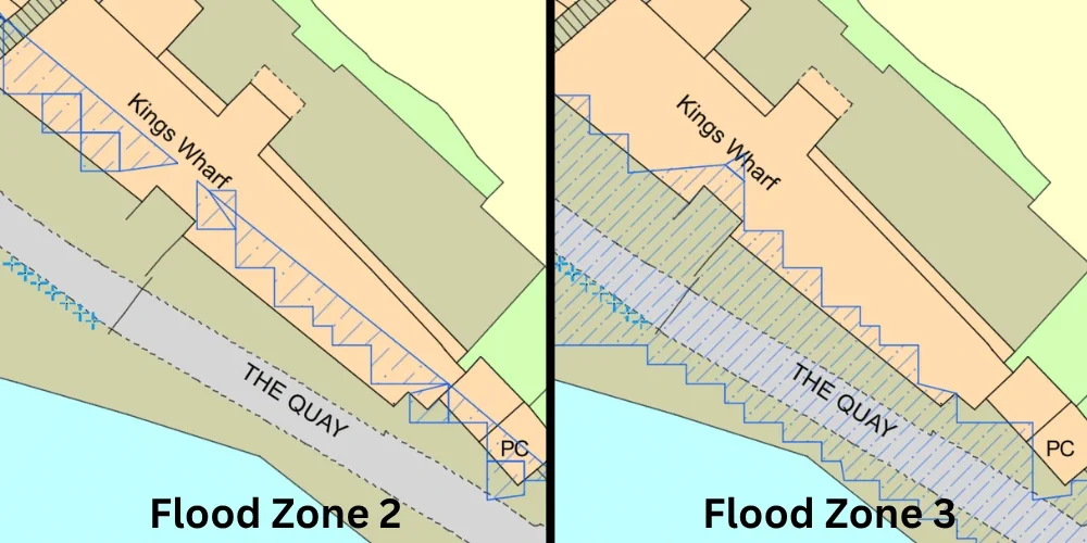
Why boundary-level mapping matters
Flood zones do not follow ownership boundaries, title plans or red line application areas. They follow modelled flood extents.
That creates a common problem during feasibility: the project team may know that a site is “in Flood Zone 2” or “near Flood Zone 3”, but not understand exactly how the flood zone interacts with the proposed development.
Boundary-level flood mapping helps answer questions such as:
- Does Flood Zone 3 touch the proposed building?
- Is the access route affected?
- Is only part of the garden, yard or open space constrained?
- Could the layout be moved to a lower-risk area?
- Does the site need a different planning strategy?
- Should a flood risk consultant be appointed before submission?
This level of detail is especially useful for architects working in CAD, because the flood constraint can be reviewed against the proposed layout rather than considered as a separate map image.
How Flood Zone 2 and Flood Zone 3 affect design
Flood risk can influence design long before a planning application is submitted.
If a site is in Flood Zone 2 or 3, the design team may need to consider:
- building position
- finished floor levels
- access and escape routes
- basements
- external levels
- parking location
- plant and equipment
- storage areas
- residential accommodation at ground floor
- emergency planning
- relationship to neighbouring land
- future climate change allowances
These issues are easier to address at concept stage than after drawings, reports and consultant inputs have already been prepared.
For example, moving a building footprint early in the design process may be relatively straightforward. Moving it after a full planning pack has been prepared can affect elevations, drainage, landscape design, access, daylight, ecology, tree constraints and viability.
Flood risk is therefore not just an environmental issue. It is a design coordination issue.
Flood Zone 2 vs Flood Zone 3 for developers
For developers and land professionals, the difference between Flood Zone 2 and Flood Zone 3 can affect both planning risk and land value.
A site in Flood Zone 2 may still be attractive, but it should be checked properly before assumptions are made about density, layout, timescales or consultant costs.
A site in Flood Zone 3 may still have potential, but the planning risk is usually higher. The developer may need to consider whether:
- the developable area is reduced
- a different layout would be needed
- more technical evidence is required
- planning determination could take longer
- the Local Planning Authority may resist the proposal
- mitigation costs could affect viability
- insurance, saleability or funder concerns may arise later
This does not mean Flood Zone 3 sites should always be avoided. It means they should be assessed properly before commercial decisions are made.
A flood risk map can help developers understand the constraint early enough to make a better-informed decision.
Flood Zone 2 vs Flood Zone 3 for architects
For architects, flood zone information should be considered before the proposed layout is fixed.
A flood constraint may affect:
- where the building can sit
- whether the entrance position is suitable
- whether ground floor accommodation is appropriate
- whether the proposal needs raised thresholds
- whether an access route remains safe
- whether external spaces need to be rearranged
- whether the scheme needs specialist flood input before planning
The risk is not just that the planning application is refused. The more common commercial risk is redesign.
If flood risk is discovered late, the architect may need to revise drawings, coordinate new consultant advice and explain to the client why the scheme has changed.
Checking Flood Zone 2 and Flood Zone 3 early helps avoid this.
Flood Zone 2 vs Flood Zone 3 for planning consultants
For planning consultants, flood zone information helps shape the planning route.
It can influence:
- planning appraisal advice
- application validation requirements
- Sequential Test strategy
- Exception Test considerations
- consultant team recommendations
- likely objections or consultation responses
- whether pre-application advice is useful
- what needs to be explained in the planning statement
A site in Flood Zone 2 may need a different level of evidence from a site in Flood Zone 3. A site partly within Flood Zone 3 may need a different approach from a site wholly within it.
Accurate mapping gives the planning consultant a stronger basis for early advice.
Climate change and Flood Zones 2 and 3
Planning flood risk is not only about present-day flood extents. Climate change can increase future flood risk over the lifetime of a development.
For some applications, especially larger or more vulnerable schemes, climate change allowances may affect the evidence required and the design response.
A site that appears acceptable under present-day mapping may still need further assessment where future flood risk is relevant.
For early-stage feasibility, this is another reason not to treat flood mapping as a box-ticking exercise.
Common misconceptions about Flood Zone 2 and Flood Zone 3
Misconception 1: Flood Zone 2 means the site is safe
Flood Zone 2 is lower risk than Flood Zone 3, but it is still a planning flood zone. It can still trigger further checks, affect design and require evidence.
Misconception 2: Flood Zone 3 means the site cannot be developed
Flood Zone 3 is more constrained, but it does not automatically rule out development. The outcome depends on the proposal, vulnerability classification, local policy, site-specific evidence and mitigation.
Misconception 3: Only the building footprint matters
Access, escape, external levels and surrounding land can all matter. A building outside a flood zone may still face planning issues if access is affected.
Misconception 4: A screenshot is enough for professional planning work
Screenshots may be useful for an initial conversation, but they are not ideal for design coordination, CAD workflows or detailed feasibility checks.
Misconception 5: Flood risk can be checked after the design is complete
This is risky. Flood risk can affect layout, levels, access and consultant requirements. It should be checked before key design decisions are fixed.
How to check whether a site is in Flood Zone 2 or 3
A basic online check can help identify whether a site may be affected, but professional teams usually need more than a general map view.
For planning and design work, it is useful to have flood risk data shown against accurate base mapping, site context and deliverable formats that can be shared with the project team.
Flood risk should also be reviewed alongside wider site constraints using a planning constraints map, especially where flooding may affect layout, access, viability or the need for further planning evidence.
This is useful where the team needs to:
- understand whether the red line boundary is affected
- check the proposed building footprint
- review access routes
- brief a flood risk consultant
- assess whether the layout should change
- support early planning feasibility
- reduce the risk of validation or consultation delays
How MapServe helps with Flood Zone 2 and 3 checks
MapServe supports architects, planning consultants, surveyors, developers and land professionals who need clear flood risk mapping before progressing a planning application.
A MapServe Flood Risk Map can help you:
- identify whether a site falls within Flood Zone 2 or Flood Zone 3
- view flood risk alongside OS MasterMap® site context
- understand whether only part of a site is affected
- support planning feasibility and due diligence
- coordinate flood constraints with CAD-based design work
- brief consultants and clients with clearer spatial information
- reduce the chance of late-stage redesign
The purpose is not just to check whether a site is in a flood zone. It is to understand how that flood zone affects the planning application, the layout and the commercial risk of the project.
For early-stage planning, land appraisal and design coordination, a flood risk map is one of the simplest ways to identify whether Flood Zone 2 or Flood Zone 3 could affect the scheme.
Order a professional flood risk map from MapServe.
FAQs
Which is worse, Flood Zone 2 or Flood Zone 3?
Flood Zone 3 is generally more significant because it represents a higher probability of flooding from rivers or the sea than Flood Zone 2.
Is Flood Zone 2 low risk?
Flood Zone 2 is generally treated as medium probability for planning purposes. It is lower risk than Flood Zone 3, but it can still affect planning applications and may require supporting flood risk evidence.
Does Flood Zone 3 mean I cannot build?
No, not automatically. Development may still be possible in Flood Zone 3, but the proposal will usually need careful flood risk assessment, planning justification and suitable mitigation.
Do Flood Zones 2 and 3 include surface water flooding?
No. Flood Zones 2 and 3 in the Flood Map for Planning relate to flooding from rivers and the sea. Surface water flood risk should be checked separately where relevant.
Can part of a site be in Flood Zone 3?
Yes. A site can be partly within Flood Zone 3. This is why site-specific mapping is important, especially when the flood zone affects only part of the boundary, access route or proposed layout.
Do I need a Flood Risk Assessment in Flood Zone 2?
A Flood Risk Assessment may be required for development in Flood Zone 2, depending on the proposal and local planning requirements. It is best to check this early before preparing a planning submission.
Should architects check Flood Zones before drawing the layout?
Yes. Flood risk can affect building position, access, floor levels, external works and the evidence needed for planning. Checking early can reduce redesign risk.
What is the best way to compare Flood Zone 2 and Flood Zone 3 on a site?
The best approach is to use a site-specific flood risk map that shows Flood Zones 2 and 3 alongside accurate base mapping, boundaries, buildings, roads and proposed layout information.