
If you work in architecture, surveying or planning, you’ve almost certainly come across OS MasterMap®. But despite how widely it’s referenced, it’s often misunderstood — particularly how it differs from other Ordnance Survey maps and when it should (and shouldn’t) be used.
This guide explains what OS MasterMap is, why it exists, and when it’s the right choice for professional projects.
What is OS MasterMap®?
OS MasterMap® is Ordnance Survey’s most detailed large-scale geographic dataset. Unlike traditional maps that are designed primarily for viewing, OS MasterMap® is a feature-based dataset created for professional and commercial use.
Every real-world feature — buildings, roads, paths, land parcels and physical structures — is captured as an individual object with precise geometry and attribution. This makes OS MasterMap fundamentally different from smaller-scale OS maps.
In practical terms, it means:
-
Buildings are mapped as discrete objects
-
Roads, footpaths and access routes are clearly defined
-
Urban detail is captured to a level suitable for planning and design work
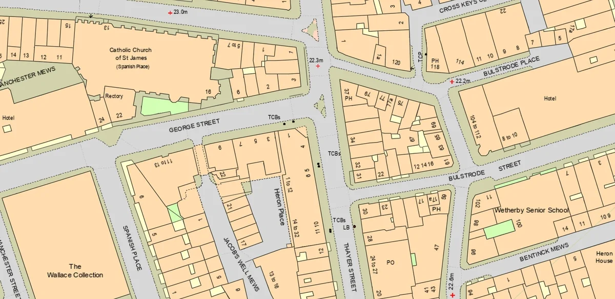
OS MasterMap® sample
Why OS MasterMap is the industry standard for planning and CAD
OS MasterMap is widely regarded as the industry standard base map for UK planning, surveying and architectural workflows.
That’s because it offers:
-
High positional accuracy suitable for design work
-
Consistent national coverage
-
Regular updates from survey and aerial sources
-
Compatibility with CAD and GIS environments
For many UK local planning authorities, OS MasterMap® is the expected baseline for submitted plans and drawings.
How professionals typically use OS MasterMap®
Planning applications
OS MasterMap is commonly used to show:
-
Existing site context
-
Neighbouring buildings and access
-
Accurate boundaries and surrounding features
Its level of detail makes it appropriate for existing site plans and design overlays submitted as part of householder or full planning applications.
Architectural design & CAD base plans
Architects frequently use OS MasterMap as a starting point for:
-
Concept layouts
-
Feasibility studies
-
Alignment with measured surveys
Because it represents features as objects rather than simple lines, it integrates well with professional CAD workflows.
Surveying & site analysis
Surveyors use OS MasterMap® to understand:
-
The physical arrangement of a site
-
Relationships between buildings, land and infrastructure
-
Constraints and access considerations
It provides a reliable context layer that complements on-site survey data.
OS MasterMap® vs other Ordnance Survey maps
A common source of confusion is how OS MasterMap differs from other OS products.
In simple terms:
-
OS MasterMap®
Best for planning, CAD, surveying and professional analysis
Most detailed, licensed for commercial use -
OS Vector Map
Best for regional or strategic context
Not detailed enough for site-level planning -
OS Explorer / Landranger
Designed for recreation and navigation
Not suitable for professional or planning use
If you need feature-level detail for a specific site, OS MasterMap is almost always the correct choice.
Licensing matters (and why it’s important)
OS MasterMap® is licensed data, not open mapping. That matters.
Using properly licensed OS MasterMap® data ensures:
-
Compliance with Ordnance Survey terms
-
Acceptance for professional and planning use
-
Confidence that the data is legitimate and current
When sourcing OS MasterMap, it’s important to use a supplier that provides the data under the correct licence for commercial and professional projects.
When should you use OS MasterMap?
You should strongly consider OS MasterMap® if you are:
-
Submitting or supporting a UK planning application
-
Producing CAD drawings for architectural design
-
Carrying out site feasibility or constraints analysis
-
Working on surveying or land-based professional projects
For less detailed, non-professional or illustrative mapping, a smaller-scale OS product may be sufficient — but for technical work, OS MasterMap® remains the benchmark.
Ordering OS MasterMap® for professional use
If you need OS MasterMap® data for planning, CAD or surveying, you can order licensed datasets prepared specifically for professional workflows.
👉 OS MasterMap® mapping for planning and professional use
MapServe® supplies OS MasterMap® data in formats suitable for architects, surveyors and planners, with options to combine it with additional professional datasets where required.