When preparing drawings for a UK planning application, OS MasterMap® is commonly used as the base mapping due to its level of detail and acceptance by local planning authorities.. Using the wrong type of map can lead to delays, validation issues, or requests for resubmission.
This article explains why OS MasterMap® is commonly used for planning applications, what it’s suitable for, and how professionals typically use it when preparing planning drawings.
Why base mapping matters for planning submissions
Local planning authorities require submitted drawings to:
-
Accurately represent the site and its surroundings
-
Show neighbouring buildings, access and context
-
Be to an appropriate scale and level of detail
While several Ordnance Survey products exist, not all are suitable for professional planning use. Recreational or illustrative maps often lack the precision and feature detail needed for validation.
Why OS MasterMap® is widely used for planning
OS MasterMap® is Ordnance Survey’s most detailed large-scale mapping product and is commonly used by architects, planning consultants and surveyors when preparing planning drawings.
It is well suited to planning because it:
-
Accurately shows buildings, roads, paths and land features
-
Provides reliable site context and neighbouring detail
-
Aligns well with measured surveys and CAD workflows
-
Is recognised and accepted across UK planning authorities
For existing site plans and design overlays, OS MasterMap® is often the expected baseline.
Typical planning drawings that use OS MasterMap®
Existing site plans
OS MasterMap® is frequently used to show:
-
The application site
-
Adjacent buildings and land
-
Access routes and surrounding context
This allows planning officers to clearly understand how a proposal relates to its surroundings.
Proposed plans and overlays
Architects often overlay proposed works onto OS MasterMap® data to:
-
Demonstrate scale and positioning
-
Show relationships with neighbouring properties
-
Provide clarity at validation stage
Location and block plans
For many applications, OS MasterMap® forms the basis of:
-
Location plans
-
Block plans
-
Supporting drawings submitted alongside design statements
OS MasterMap® vs other OS maps for planning
A common mistake is assuming all Ordnance Survey maps are interchangeable.
In practice:
-
OS MasterMap®
Suitable for professional planning use
Feature-level detail, licensed for commercial projects -
OS Vector Map
Useful for wider context
Often too general for site-specific planning drawings -
OS Explorer / Landranger
Designed for navigation and recreation
Not suitable for planning submissions
If a drawing needs to stand up to scrutiny during validation, OS MasterMap® is usually the safest choice.
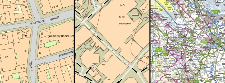
OS MasterMap® OS Vector Map OS Explorer Map
Licensing and compliance
OS MasterMap® is licensed data. Using properly licensed mapping helps ensure:
-
Compliance with Ordnance Survey terms
-
Acceptance for professional and planning use
-
Confidence that submitted drawings are legitimate
Planning professionals should always ensure the mapping they use is supplied under the correct licence for commercial work.
Ordering OS MasterMap for planning applications
If you are preparing drawings for a planning application and need reliable, professional base mapping, OS MasterMap® is designed for exactly this purpose.
👉 OS MasterMap® mapping for planning and professional use
MapServe supplies licensed OS MasterMap data suitable for planning, architectural and surveying workflows, with options to combine it with additional professional datasets where required.