
The OS National Geographic Database (NGD) and MasterMap® are closely related — but they are not the same thing.
If you work with professional Ordnance Survey data, understanding the distinction is important for planning, engineering and GIS workflows.
This article explains:
-
What the OS NGD is
-
What MasterMap® is
-
How they relate
-
What professionals actually download from MapServe®
Quick Answer
-
OS NGD is the core national geospatial database maintained by Ordnance Survey.
-
MasterMap® is a product derived from that database.
-
Professionals access structured extracts of this data via licensed suppliers such as MapServe®.
What Is the OS National Geographic Database (NGD)?
The OS National Geographic Database (NGD) is the central geospatial data repository maintained by Ordnance Survey.
It contains structured, object-level data representing:
-
Buildings
-
Roads
-
Rail infrastructure
-
Land parcels
-
Water features
-
Boundaries
-
Terrain
The NGD is not a downloadable “map.”
It is a continuously maintained spatial database.
You can learn more about professional Ordnance Survey datasets here:
What Is MasterMap®?
MasterMap® is a commercial product derived from the NGD.
It provides:
-
Large-scale, detailed topographic mapping
-
Structured vector data
-
Layered thematic datasets
-
Survey-grade positional accuracy
Each mapped feature includes a TOID (Topographic Identifier), allowing integration into GIS systems and asset management platforms.
The Key Difference
The simplest way to understand it:
| OS NGD | MasterMap® |
|---|---|
| National geospatial database | Commercial product |
| Maintained centrally by Ordnance Survey | Extracted dataset derived from NGD |
| Not directly downloaded | Supplied to professionals |
| Underpins multiple OS products | Used for planning and design |
The NGD is the source.
MasterMap® is a structured output.
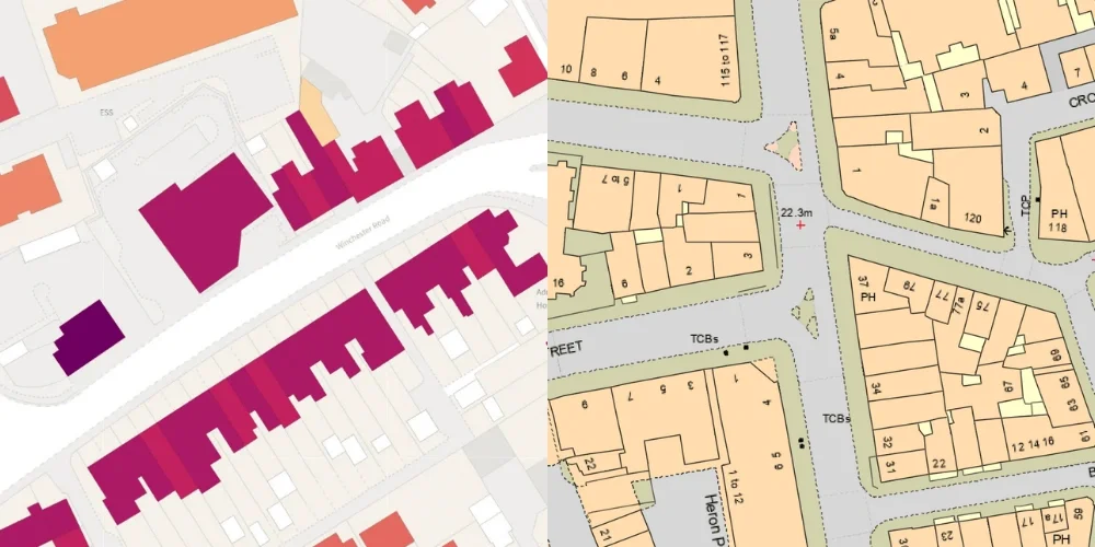
OS NGD sample vs OS MasterMap® sample
How Professionals Access the Data
Professionals do not directly access the raw NGD.
Instead:
-
Ordnance Survey maintains the NGD.
-
Licensed partners access the data under agreement.
-
Site-specific extracts are generated.
-
The mapping is supplied in usable formats.
When you download OS maps from MapServe®, you are receiving licensed extracts derived from the NGD, commonly delivered as:
-
DWG
-
DXF
-
PDF
Is NGD Replacing MasterMap®?
No.
The NGD is the underlying database framework.
MasterMap® remains a structured commercial dataset derived from that framework.
Think of the NGD as the engine.
MasterMap® is one of the primary outputs.
Where 1:1250 and 1:2500 Mapping Fit In
Large-scale mapping products such as:
-
1:1250
-
1:2500
are also derived from the NGD.
These are typically used for:
-
Planning applications
-
Site location plans
-
Block plans
Professional planning drawings are based on NGD-derived datasets supplied via licensed providers.
Why This Distinction Matters
Understanding the NGD vs MasterMap® distinction matters because:
-
It clarifies what you are licensing
-
It explains how updates flow into datasets
-
It reinforces why OS mapping is authoritative
-
It supports compliance in professional workflows
The data originates from a continuously maintained national geospatial database, not static mapping files.
Frequently Asked Questions
Is MasterMap® the same as NGD?
No. NGD is the national database; MasterMap® is a commercial dataset derived from it.
Can I download the NGD directly?
No. Professionals download licensed extracts derived from NGD datasets via suppliers such as MapServe®.
Is MasterMap® being discontinued?
No. It continues as a structured product derived from NGD data.
Are planning maps based on NGD data?
Yes. 1:1250 and 1:2500 mapping products are derived from NGD datasets.
Conclusion
The OS National Geographic Database (NGD) is the foundational geospatial database maintained by Ordnance Survey.
MasterMap® is a structured commercial dataset derived from that database and supplied to professionals via licensed providers such as MapServe®.
If you require authoritative OS mapping derived from NGD datasets, you can download licensed mapping directly from MapServe®.