
Why Historic Mapping Matters in Planning and Heritage
Historic Ordnance Survey maps are a powerful form of evidence. They are routinely used to:
-
Demonstrate building chronology
-
Identify former land uses
-
Evidence lost features
-
Support or challenge heritage impact
Yet many heritage statements fail to use historic mapping properly—or at all.
This guide explains how to use MapServe’s historic OS mapping effectively and credibly in UK planning and heritage reports.
What Historic OS Maps Can (and Can’t) Prove
Historic maps can evidence:
-
Presence or absence of buildings
-
Changes in plot boundaries
-
Evolution of infrastructure
-
Former industrial or agricultural use
They cannot:
-
Precisely date construction
-
Prove internal layouts
-
Replace archival or fabric analysis
Used correctly, they are contextual evidence, not sole proof.
1. Establishing Building Chronology
By comparing map editions over time, you can:
-
Identify when a building first appears
-
Track extensions or demolitions
-
Support estimated construction periods
Best practice is to:
-
Use multiple editions
-
Clearly state date ranges
-
Avoid over-precise claims
2. Evidencing Plot Boundaries and Enclosures
Historic OS maps often show:
-
Field boundaries
-
Walls, hedges and enclosures
-
Access routes and tracks
This can support arguments around:
-
Historic curtilage
-
Long-established boundaries
-
Character and setting
3. Identifying Former Land Uses
Mapping can reveal:
-
Quarries
-
Mills
-
Railways
-
Agricultural patterns
This is valuable for:
-
Heritage significance assessments
-
Contamination context
-
Explaining site character evolution
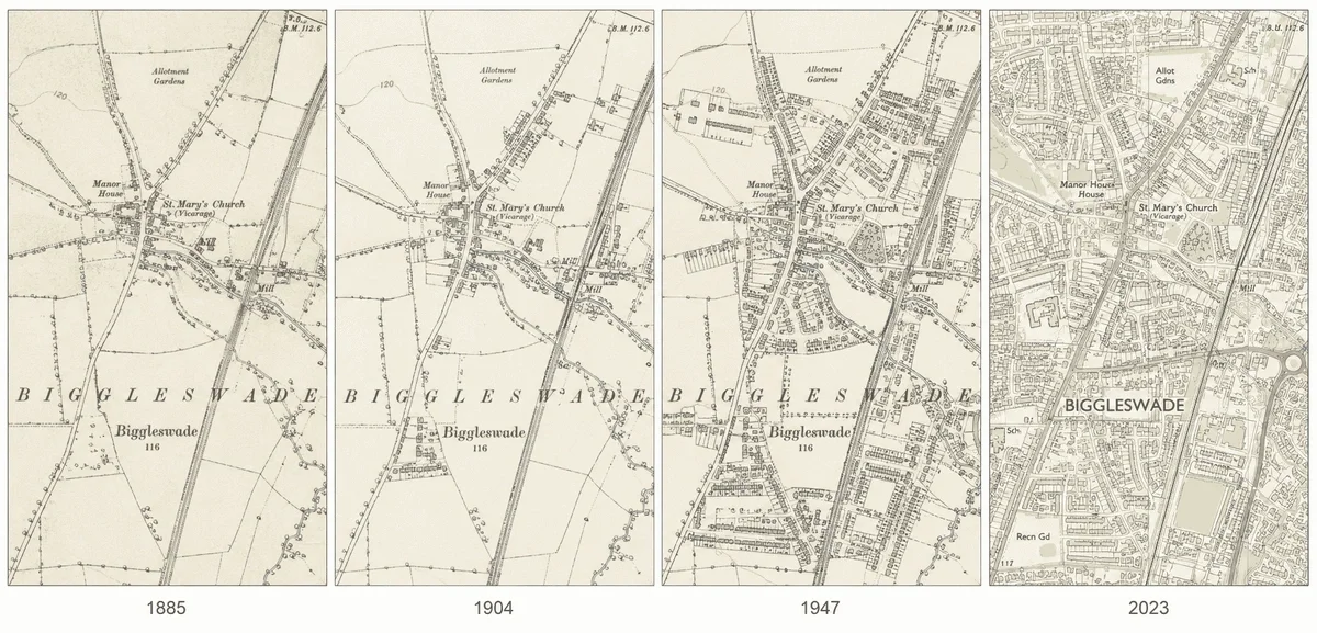
4. Capturing Change-Over-Time Visuals
Screenshots showing multiple map dates are persuasive.
Tips:
-
Use consistent extents
-
Label dates clearly
-
Avoid clutter
MapServe’s historic mapping allows clean comparisons suitable for reports.
5. Basic Geo-Referencing for Context
Geo-referencing allows historic maps to be aligned with modern mapping.
This helps:
-
Compare past and present layouts
-
Show loss or survival of features
-
Improve clarity for non-technical readers
For heritage statements, approximate alignment is usually sufficient—precision GIS is rarely required.
6. Citing Map Editions Correctly
Always include:
-
Map scale
-
Publication date
-
Source
This strengthens credibility and avoids challenges from consultees.
7. Using Historic Maps Proportionately
Overuse can dilute impact. Use historic mapping to:
-
Support key points
-
Illustrate change
-
Provide context
Avoid dumping large numbers of maps without commentary.
Why MapServe Historic Mapping Works for Heritage Reports
MapServe provides:
-
Access to multiple historic OS editions
-
Clear, legible mapping extracts
-
Data suitable for reports and appendices
This makes it easier to build defensible, professional heritage evidence.
Final Thoughts
Historic OS maps are one of the most effective—and under-used—tools in heritage planning.
When selected carefully, cited correctly and explained clearly, they:
-
Strengthen heritage statements
-
Improve planning outcomes
-
Reduce objections and uncertainty
MapServe’s historic mapping makes this process faster, clearer and more reliable.