Searching for a free property boundaries map is often the first step for architects, homeowners, and developers preparing a planning application.
It makes sense. Why pay for mapping when free tools exist?
But here’s the problem:
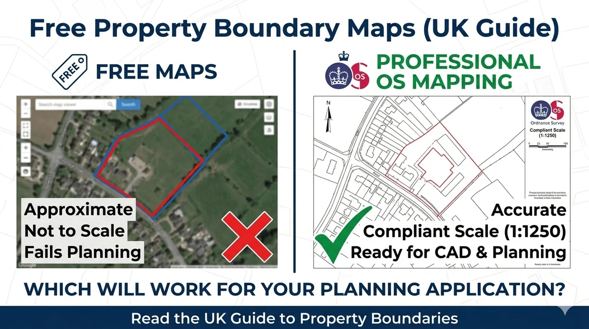
Most free boundary maps are not suitable for planning, design, or legal use.
This guide explains:
-
Where free boundary maps come from
-
Why they fail planning validation
-
When you can (and cannot) use them
-
What professionals use instead
What Is a Property Boundary Map?
A property boundary map shows the extent of land ownership or occupation.
In the UK, boundaries are typically derived from:
-
HM Land Registry title plans
-
Surveyed site data
However, not all boundary data is created equal.
Where Do Free Property Boundary Maps Come From?
Free boundary maps usually come from:
1. HM Land Registry (Title Plans)
-
Shows general boundary extent
-
Based on OS mapping
-
Low positional accuracy
2. Online Map Viewers
-
Aggregated datasets
-
Often simplified or outdated
-
No guarantee of scale accuracy
3. Open Data Sources
-
Useful for context
-
Not suitable for measured drawings
The Problem With Free Boundary Maps
1. They Are Not Accurate Enough
Land Registry boundaries follow the “general boundary rule”.
This means:
-
Lines are approximate
-
Not tied to precise physical features
-
Can be offset by metres
For planning applications, this is a critical issue.
2. They Fail Planning Requirements
Local authorities require:
-
Scaled drawings (1:1250 / 1:500)
-
Clear red-line site boundaries
-
OS-compliant base mapping
Free maps typically fail at least one of these.
3. They Cannot Be Used in CAD Workflows
Free maps:
-
Lack DWG/DXF formats
-
Cannot be reliably scaled
-
Often misalign with survey data
This creates friction in design workflows.
When Can You Use Free Boundary Maps?
Free maps are acceptable for:
-
Initial site research
-
Feasibility studies
-
Early-stage concept discussions
They are not suitable for:
-
Planning applications
-
Legal boundary definition
-
Measured site design
What Professionals Use Instead
Architects and planners use:
OS MasterMap-Based Boundary Plans
These provide:
-
Accurate base mapping
-
Correct scale
-
Planning-compliant outputs
CAD-Ready Mapping (DWG / DXF)
Allows:
-
Seamless integration into drawings
-
Accurate overlays with surveys
-
Faster design workflows
Why Planning Applications Get Rejected
A common issue:
Boundary drawn from free map ≠ actual site extent
This leads to:
-
Incorrect red line boundary
-
Missing access areas
-
Overlapping ownership
Result?
Planning validation failure.
The Hidden Risk: Boundary Misalignment
Even when boundaries “look right”:
-
CAD overlays can shift position
-
OS data vs free data mismatch
-
Scale distortion from screenshots
These small errors cause big problems.
What a Compliant Boundary Map Includes
To meet UK planning requirements, your map must include:
-
Ordnance Survey base
-
Correct scale (1:1250 or 1:500)
-
Red line boundary
-
Blue line (other owned land, if required)
-
North arrow
-
Scale bar
Cost vs Risk: The Real Trade-Off
Free maps save money upfront.
But they risk:
-
Planning delays
-
Re-submission costs
-
Project timeline impact
A compliant map typically costs less than a planning delay.
Recommended Approach
Use free maps only for:
-
Early-stage research
Switch to professional mapping when:
-
Preparing planning drawings
-
Defining site boundaries
-
Producing CAD outputs
FAQs
1. Are free property boundary maps accurate?
No. They are based on generalised data and are not precise enough for planning or design.
2. Can I use Land Registry boundaries for planning?
Not on their own. They must be aligned with accurate OS mapping.
3. Why do councils reject boundary maps?
Because they lack correct scale, OS data, or accurate site definition.
4. What scale should a boundary map be?
Typically 1:1250 for location plans and 1:500 for block plans.
5. Do I need a paid map for planning permission?
Yes. Planning authorities require OS-based, compliant mapping.
Final Thought
Free property boundary maps are useful, but only at the right stage.
If you're moving towards planning or design, accuracy is no longer optional.