What Is a Site Analysis?
A site analysis is the foundation of any successful architectural project. It is the process of evaluating a site before design begins, ensuring that all physical, environmental, and planning constraints are understood early.
For UK architects, this stage is particularly critical due to strict planning requirements and site-specific constraints that can significantly influence design viability.
A thorough site analysis typically includes:
- Access and movement patterns
- Surrounding built context
- Topography and level changes
- Existing trees and vegetation
- Rights of way and easements
- Adjacent buildings and windows
- Boundary positions and ownership
The goal is simple: identify risks and opportunities before design fees are committed.
Too often, site analysis is treated as a visual exercise: photos, sketches, and annotations. In reality, it is a data-driven process that should begin with accurate mapping.
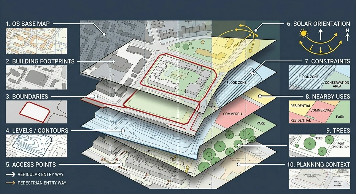
What Should a Good Site Analysis Include?
A professional site analysis drawing is layered, structured, and based on reliable geospatial data. Each layer provides a different type of insight.
1. OS Base Map
This forms the backbone of the analysis. It provides accurate building outlines, road layouts, and spatial relationships.
Without it, scale errors are almost inevitable.
2. Building Footprints
Understanding surrounding structures is essential for:
- Daylight and overshadowing studies
- Privacy assessments
- Massing decisions
3. Boundaries
Boundary clarity is critical for:
- Ownership verification
- Planning red line drawings
- Avoiding disputes
Unclear boundaries are one of the most common causes of project delays.
4. Levels / Contours
Even minor level changes affect:
- Drainage strategy
- Step-free access compliance
- Foundation design
Contour mapping is often overlooked on “flat” sites—but rarely should be.
5. Access Points
Vehicular and pedestrian access must be clearly defined early, including:
- Visibility splays
- Width constraints
- Shared access conditions
6. Solar Orientation
Understanding sun paths informs:
- Window placement
- Garden usability
- Energy performance
7. Constraints
These may include:
- Rights of way
- Conservation areas
- Flood zones
- Easements
8. Nearby Uses
Context matters. Adjacent uses influence:
- Noise considerations
- Privacy expectations
- Design suitability
9. Trees
Tree constraints can impact:
- Buildable area
- Foundation design
- Planning approval
10. Planning Context
Every site sits within a policy framework. A strong analysis aligns physical data with:
- Local planning policy
- Design codes
- Neighbourhood context
Site Analysis Example (Residential Infill Plot)
Let’s walk through a realistic UK scenario.
Site Overview
- Location: Urban London infill plot
- Access: Narrow side passage
- Topography: 1.8m level change across site
- Context: Terraced housing on both sides
- Constraints: Mature tree in neighbouring garden
Key Findings
1. Access Constraints
The narrow side access limits construction logistics and future usability. This may:
- Restrict material delivery
- Influence building footprint
- Affect fire escape compliance
2. Overshadowing Issues
Rear overshadowing is a major concern due to:
- Adjacent building height
- Limited southern exposure
This impacts:
- Daylight within the proposed dwelling
- Garden usability
3. Level Change (1.8m)
This is significant enough to affect:
- Foundation design
- Drainage gradients
- Step-free access requirements
Ignoring this early leads to redesign later.
4. Overlooking Risk
The north boundary faces neighbouring windows. This creates:
- Privacy concerns
- Potential objections during planning
Design responses may include:
- High-level windows
- Screening strategies
5. Tree Constraint
A mature tree in a neighbouring garden introduces:
- Root protection area (RPA) restrictions
- Potential foundation limitations
- Planning sensitivity
This often reduces the developable footprint more than expected.
What This Example Shows
A strong site analysis doesn’t just describe the site—it predicts design constraints before they happen.
This is where mapping-led workflows outperform traditional approaches.
Why Accurate Mapping Matters
Poor base data leads to compounding problems throughout the project lifecycle.
1. Wrong Scale Drawings
If your base plan is inaccurate:
- Dimensions are unreliable
- Designs need rework
- Planning drawings may be rejected
2. Planning Delays
Local authorities expect:
- Accurate red line boundaries
- Contextual clarity
- Consistent scale
Errors here slow validation and approval.
3. Boundary Disputes
Unclear ownership lines can result in:
- Legal complications
- Neighbour objections
- Project delays
4. Redesign Fees
Perhaps the biggest hidden cost.
If site data is wrong:
- Concept designs must be redrawn
- Consultants repeat work
- Deadlines slip
Accurate mapping is not a cost—it’s a risk reduction tool.
Best Mapping Data for Architects
Choosing the right data at the start dramatically improves workflow efficiency.
OS MasterMap®
High-detail mapping ideal for:
- Urban sites
- Dense contexts
- Planning submissions
Use it when precision matters.
Building Height Data
Critical for:
- Massing studies
- Overshadowing analysis
- Context modelling
It provides vertical insight often missing from standard plans.
1m Contours
Essential for:
- Sloped sites
- Drainage design
- Accessibility planning
Even subtle changes can influence compliance.
DWG Plans
The preferred format for most architects.
Benefits include:
- Editable layers
- Faster workflow
- Seamless integration with CAD software
Avoid tracing PDFs—start with usable data.
How MapServe® Helps
MapServe® provides instant access to professional mapping data tailored for UK architects and planning consultants.
With downloadable formats including CAD and PDF, teams can:
- Start projects with accurate base data
- Reduce redraw time
- Improve planning submission quality
- Identify risks earlier
Instead of spending hours rebuilding base plans, architects can focus on design decisions that add value.
FAQs
1. What scale should a site analysis plan be?
Typically 1:200 or 1:500 for urban sites. The scale should clearly show context, boundaries, and constraints without overcrowding the drawing.
2. Do architects need contours?
Yes, in most cases. Even small level changes affect drainage, access, and compliance with Building Regulations.
3. Can I use Google Maps for planning?
No. It is not accurate or licensed for planning submissions. Professional mapping data is required.
4. What mapping format works best in AutoCAD?
DWG is the preferred format because it allows full editing, layer control, and integration into design workflows.
5. How detailed should a UK site analysis be?
Detailed enough to identify all constraints affecting design and planning. This includes boundaries, levels, context buildings, access, and environmental factors.