If you are preparing a planning application, extension, self-build project or land sale, you may have been told you need a plot plan.
However, in the UK, this term is often misunderstood — and that confusion can lead to rejected drawings, validation delays, or costly revisions.
Architects, planners and homeowners frequently use different terminology for the same thing. What one person calls a plot plan, another might call a site plan or block plan.
This guide explains exactly what a plot plan is in the UK, when you need one, and how to get a compliant version quickly.
What Is a Plot Plan?
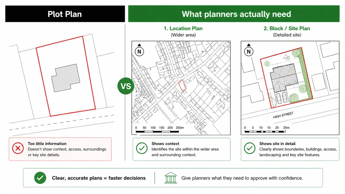
A plot plan is a scaled drawing that shows a parcel of land and the buildings or features on it.
It typically includes:
- Property boundaries
- Existing buildings
- Proposed extensions or new structures
- Access roads or driveways
- Neighbouring buildings
- A north point
- A scale bar
- Surrounding context
In simple terms, it shows how a piece of land is arranged — both now and after any proposed changes.
Why “Plot Plan” Causes Confusion in the UK
The term “plot plan” is widely used in the US, but in the UK planning system, it is not a formal requirement.
Instead, local planning authorities usually refer to:
- Location plans
- Block plans
- Site plans
- Proposed layouts
So when someone asks for a plot plan, they are typically referring to one of these.
This mismatch in terminology is one of the biggest hidden causes of planning submission errors.
Plot Plan vs Site Plan vs Block Plan
Understanding the differences is critical for avoiding delays.
Plot Plan
A general, informal term for a land layout drawing.
Site Plan
A more detailed drawing showing the existing and proposed layout of a site, often used for design and planning clarity.
Block Plan
Usually drawn at 1:500 or 1:200 scale. Shows the site, boundaries and neighbouring buildings in context.
Location Plan
Typically at 1:1250 or 1:2500 scale. Shows the site within a wider area, including surrounding roads and landmarks.
What Do You Actually Need?
For most UK planning applications, you will need:
- A location plan
- A block or site plan
Submitting only one is a common mistake that leads to validation issues.
When Do You Need a Plot Plan?
You may need a plot plan (or equivalent) for:
- House extensions
- Loft conversions
- New build homes
- Garage construction
- Commercial property changes
- Land registry or legal purposes
- Property sales packs
- Development feasibility studies
In most cases, if your project involves land or buildings, some form of scaled plan will be required.
What Scale Should a Plot Plan Be?
Using the correct scale is essential for planning approval.
Typical UK standards include:
- 1:1250 – Location plans
- 1:500 – Block or plot plans
- 1:200 – Detailed site layouts
- 1:100 – Architectural drawings
Incorrect scale is one of the most common reasons plans are rejected during validation.
Always check your local authority’s specific requirements before submitting.
What Must Be Included in a Compliant Plot Plan?
To meet planning requirements, your drawing should include:
- A red line boundary (application site)
- A blue line boundary (other land owned, if applicable)
- Roads and access points
- Existing buildings
- Surrounding structures
- A north arrow
- A clear scale ratio
- Labels and annotations
Missing any of these elements can result in delays or rejection.
Can You Use Google Maps for a Plot Plan?
In most cases, no.
Planning authorities typically reject Google Maps screenshots because:
- They are not drawn to a certified scale
- They may breach copyright/licensing rules
- They lack clarity when printed
- Boundaries are often inaccurate
Professional mapping based on Ordnance Survey data is the standard expected for planning applications.
How to Get a Plot Plan Quickly
The fastest and most reliable way to get a compliant plot plan is to order one from a professional mapping provider.
A good provider will offer:
- UK-wide mapping coverage
- Planning-ready drawings
- Correct scales for submission
- PDF and CAD (DWG/DXF) formats
- Fast turnaround
This is particularly useful for architects, planning consultants and homeowners working to tight deadlines.
Common Mistakes to Avoid
1. Ordering Only a Location Plan
Many applicants assume one plan is enough — but most councils require both a location plan and a block/site plan.
2. Using the Wrong Scale
Even if the drawing looks correct, the wrong scale can lead to rejection.
3. Missing Red Boundary Line
This is one of the most common validation issues.
4. Lack of Context Buildings
If neighbouring structures are missing, planners may request revisions.
5. Unclear Proposed Works
Changes must be clearly visible — ambiguity leads to delays.
FAQs
Is a plot plan the same as a site plan?
They are often used interchangeably, but terminology varies by project and authority.
What scale is a plot plan?
Usually 1:500 or 1:200, depending on the purpose.
Can I create my own plot plan?
Yes, but it must meet all planning requirements to be accepted.
How much does a plot plan cost?
Costs vary depending on size, format and supplier.
Do I need a plot plan for an extension?
In most cases, yes — especially for planning applications.
Final Thoughts
In the UK, a “plot plan” is less about a specific drawing type and more about understanding what planners actually require.
Getting the terminology — and the technical details — right from the start can save significant time, cost and frustration.
If in doubt, focus on delivering:
- The correct plan type
- The correct scale
- Clear and compliant information
That’s what ensures a smooth planning process.