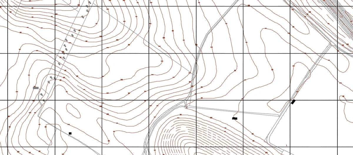
With UK site costs escalating and margins tightening under mounting planning obligations, topographic precision is now a necessity, not a luxury. MapServe®’s 1m contour data, which are sourced from high-resolution LiDAR and integrated with OS MasterMap® offers critical early visibility into five of the most common and costly site risks. From unanticipated drainage flows to inaccessible gradients and hidden excavation demands, this data reveals problems before they become expensive to fix.
1. Slope‑induced drainage issues
1m contours show exactly where water will flow, accumulate or pond. In a recent flood mitigation study, 1 m LiDAR enabled planners to identify surface water ponding and flow pathways during a 1 % annual exceedance event—ponding up to 0.6 m deep. This high‑resolution data means drainage layouts, culverts and outfalls can be aligned to natural fall from the outset, avoiding redesign, flooding and failed planning conditions.
UK context: Defra increasingly demands Natural Flood Management (NFM) and Sustainable Drainage Systems (SuDS). Contours let you verify that attenuation ponds and swales follow natural gradients, reducing reliance on pipework and lowering runoff rates to greenfield levels.
2. Level‑access conflicts
Accessibility requirements under Part M and BS 8300 demand gentle gradients across entrances and pedestrian routes. A site may look flat, but 1m contours reveal subtle falls (e.g. 3 – 5 %) requiring ramps or retaining. Early detection prevents costly last‑minute redesigns or non‑compliant rework, especially where public realm, disability access and emergency routes intersect topography.
3. Hidden excavation and earthworks
Contour data lets you calculate cut-and-fill volumes accurately before site mobilisation. Early grasp of slope changes avoids discovery-stage excavation that blows budgets. MapServe® contoured DWG/DXF exports are CAD‑ready, facilitating volume scripts and earth‑moving analysis instantly. Minimising soil infiltration also helps avoid unexpected sediment control costs.
4. Flood‑risk hotspots
1m contours overlay flood zone and surface water maps to pinpoint areas where the site is in Flood Zone 1 yet still prone to pluvial ponding. Detecting low spots where water accumulates—despite official fluvial data—helps planners avoid costly climate risk adjustments later.
5. SuDS and drainage layout clashes
High‑resolution contour data supports SuDS design that aligns with natural catchment sub‑areas, preventing attenuation systems being silted or surcharged. UK design principles require sub‑catchment attenuation basins to manage the 30‑year rainfall event plus climate allowance—the contours show catchment boundaries and gradient breaks that define where those basins should go.
Why 1m contours outperforms lower‑resolution alternatives
-
LiDAR‑derived vertical accuracy: ±0.15 m RMSE with annual updates ensures reliability across urban/rural areas.
-
CAD/GIS ready: Delivered in DWG and DXF, directly layered into site models for grading and 3D massing.
-
Nationwide OS coverage: England, Wales and large parts of Scotland in 1m resolution; urban areas within ±1 m vertical accuracy.
Best practice workflow
-
Baseline acquisition
Acquire 1m contours through MapServe® alongside OS MasterMap® buildings and boundary layers. -
Overlay flood and SuDS info
Layer Risk of Flooding maps (RoFSW), Environment Agency flood zones and local authority SuDS guidance. -
Conduct slope/fall checks
Use contour spacing to calculate gradients along access routes, drainage lines and building footprints. -
Volume and earthwork analysis
Integrate with CAD tools to estimate cut-and-fill, informing excavator quotes and site set‑up. -
Iterate drainage and access layouts
Align SuDS basins and vehicle/pedestrian access with natural depressions and gradients before planning.
Benefits in cost, time, compliance
-
Financial savings: In-house site slope and volume assessment eliminates multiple survey costs.
-
Time saved: Downloadable CAD layers switch site analysis from surveyor-led fieldwork to immediate desktop appraisal.
-
Design quality and compliance: Early drainage and access modelling reduces risk of non‑compliance with planning and building regs—including Part M, SuDS approvals and flood strategy.
-
Risk reduction: Early surfacing of ponding and slope hazards prevents late-stage redesign delays, contractor claims, and extra excavation
UK sector outlook
UK planning authorities are mandating climate resilience, draining strategies, and build‑out metrics. For example, Environment Agency flood policy update (2021) highlights innovative tech—like LiDAR‑based contour mapping—as essential tools for mitigation to 2050. At the same time, TfL and local highway authorities insist SuDS and access must follow precise gradient thresholds.
In the UK context of escalating site costs, compliance complexity, and climate‑induced flooding, 1 m contour data is not a luxury—it’s indispensable. MapServe®’s LiDAR‑derived contours deliver near‑instant insights into drainage, access, earthworks, flood risk and SuDS alignment. Professionals who stitch this into early-stage design gain accuracy, reduce risk and ultimately save money.