The Metropolitan Green Belt, encompassing over 500,000 hectares, was established through the Town and Country Planning Act of 1947. Its principal function has been to limit urban sprawl around Greater London by preserving open land, separating urban areas, and assisting in urban regeneration.
Policy Background and Objectives
The Green Belt policy is governed by five objectives outlined in the National Planning Policy Framework (NPPF):
-
To check the unrestricted sprawl of large built-up areas.
-
To prevent neighbouring towns from merging into one another.
-
To assist in safeguarding the countryside from encroachment.
-
To preserve the setting and special character of historic towns.
-
To assist in urban regeneration by encouraging the recycling of derelict and other urban land.
However, as of 2025, only 13 percent of the Metropolitan Green Belt is publicly accessible parkland. The remainder comprises private farmland, golf courses, depots, and institutional land.
Housing Demand and Supply Context
London has experienced a persistent shortfall in housing delivery. According to data from the Greater London Authority and the Planning and Regeneration Committee, the city faces a deficit of approximately 50,000 homes annually. Between 2020 and 2023, average annual completions were under 38,000, with only 32,160 homes delivered in 2023/24. This rate falls significantly short of the target required to meet demand over the next decade.
The affordability gap continues to widen. Office for National Statistics data shows that rental costs in London increased by 6.9 percent in the year to January 2024, with further rises into 2025. Temporary accommodation now houses over 61,000 households, costing boroughs over £4 million per day.
Green Belt Reform and Grey Belt Classification
In response, the Mayor of London and national planning authorities have proposed revisions to Green Belt protections. These include the identification of a new land designation: the 'Grey Belt'. Grey Belt land refers to previously developed or low-quality land within the Green Belt that fails to meet its original policy functions and lies within walking distance (800 metres) of mass transit infrastructure.
According to the December 2024 NPPF amendment, development on such land is not considered inappropriate if it meets the following criteria:
-
There is a clearly evidenced need for development.
-
The site is in a sustainable location.
-
Harm to the Green Belt is minimised.
-
Development complies with environmental and design requirements.
The Mayor's draft London Plan outlines additional non-negotiable conditions:
-
Minimum 40 percent affordable housing.
-
20 percent biodiversity net gain.
-
Guaranteed public green space within five minutes' walk.
-
Alignment with local design codes or review by a Greater London Authority design panel.
-
Direct proximity to funded or operational transit infrastructure.
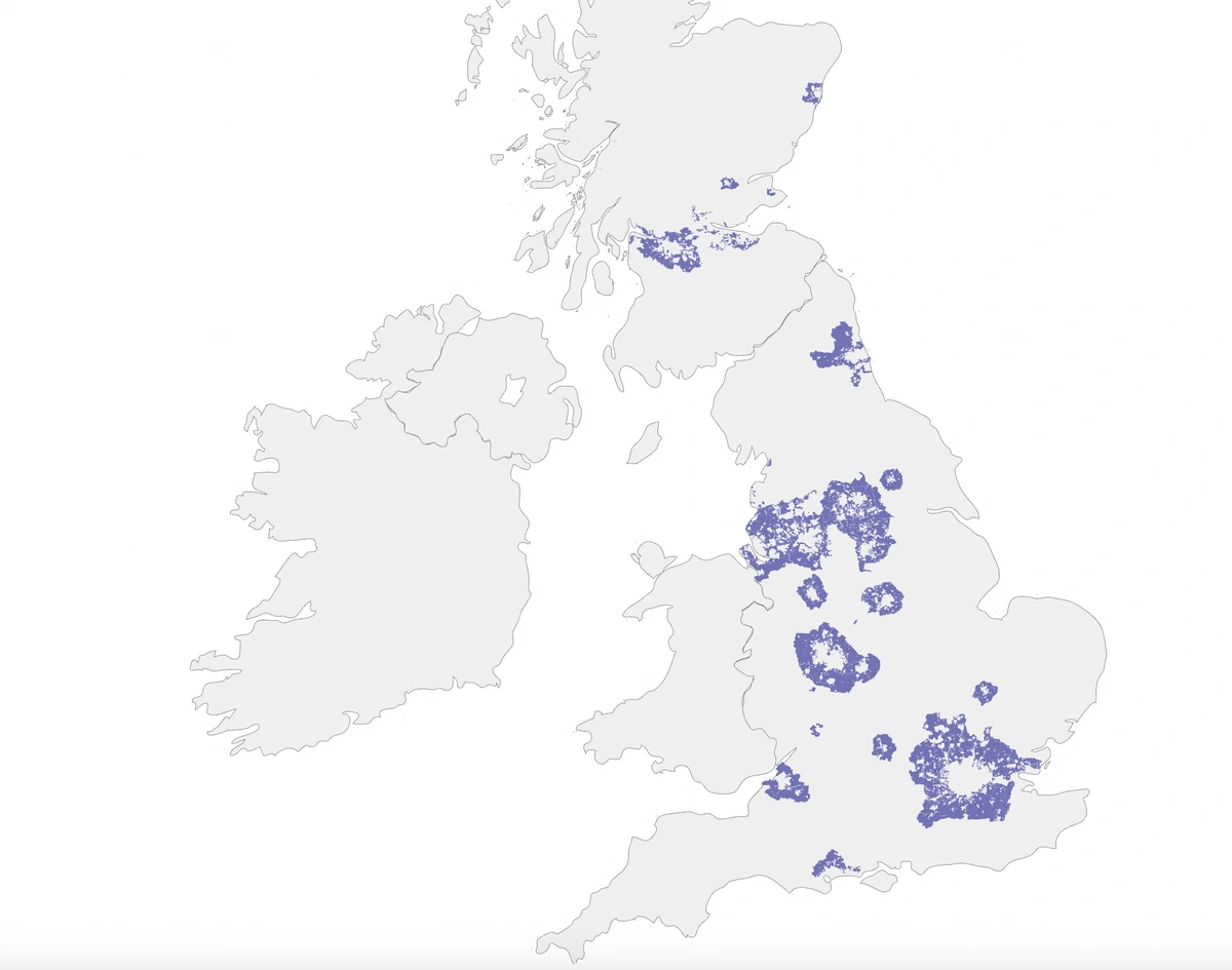
Green belt areas in England & Scotland
Site Identification and Planning Corridors
City Hall has identified four principal corridors for development under this framework:
-
Lea Valley (Enfield/Waltham Forest): Potential for up to 22,000 homes.
-
Hainault–Fairlop (Redbridge): Potential for 6,000–8,000 homes.
-
West London Orbital (Brent/Ealing): Approximately 27,000 homes possible.
-
Cray Valley (Bromley/Bexley): Estimated capacity of 7,000 homes.
These sites are located near existing or funded rail corridors and are characterised by previously developed or underutilised land parcels.
Mapping and Geospatial Analysis Tools
Precise mapping is essential for identifying potential development land within Green Belt and Grey Belt categories. Geospatial datasets and tools, such as those offered by MapServe®, support professionals by providing:
-
OS MapServe® and OS VectorMap District data.
-
Planning boundary overlays.
-
Historic land use maps.
-
Topographic and cadastral datasets.
-
Flood risk and transport proximity layers.
These tools allow for site-specific assessments that account for biodiversity constraints, transport access, and proximity to existing infrastructure. They are particularly useful in preparing viability reports, planning applications, and environmental impact assessments.
Planning Application Process and Constraints
Development proposals on Grey Belt land must undergo a two-stage referral process under the London Plan:
-
Stage One – Pre-determination review by GLA officers: Assessment of policy compliance and negotiation of Section 106 agreements.
-
Stage Two – Post-committee decision by Mayor of London: Final determination based on alignment with strategic objectives.
Permissions may be time-limited with a three-year deadline for commencement. Failure to begin work within this window can result in the reversion of land to full Green Belt status.
Implications for Stakeholders
For developers:
-
Lower land acquisition costs may improve viability.
-
Planning requirements impose higher standards of biodiversity, design, and affordability.
-
Development aligned with infrastructure investment may qualify for accelerated approvals.
For landowners:
-
Grey Belt classification may increase land value significantly.
-
Assessment tools are necessary to determine eligibility and maximise planning potential.
For policymakers and local planning authorities:
-
Parcel-level ecological assessments and infrastructure impact analyses are required.
-
Community engagement will be necessary to address resistance and ensure public benefit.
Conclusion
The reform of the Metropolitan Green Belt represents a data-driven response to severe housing shortages. The reclassification of low-quality, inaccessible land as Grey Belt enables targeted development without compromising core planning principles.
Mapping platforms such as MapServe® provide the essential tools required for evaluating site potential under the revised policy landscape. Accurate mapping, combined with up-to-date planning data, will be fundamental to successful land allocation, environmental protection, and sustainable growth.