What you need to submit
Your application must include the following elements:
- The site's required plans.
- The necessary supporting documents.
- The finished form.
- Correct payment of the fee.
If you apply online, your application will be instantly received by the relevant Local Planning Authority(LPA) once you submit it. The LPA will not be able to complete your application until the required supporting material has been given. You may also provide any additional relevant material that you believe will assist the local authorities in determining the application.
Download your planning application maps here
Location Plan
• The location plan should be at an identifiable standard metric scale (usually 1:1250 or 1:2500 for bigger locations) and specify the direction north.
• It should be resized to fit on an A4 paper.
• Demonstrate sufficient roads and/or structures on land adjacent to the application location.
• Outline in red the application site borders as well as all land required to carry out the planned development, such as property required for access to the site from the road. A blue line should be drawn around any additional land owned by the applicant that is near to, or contiguous to the property.
A location plan is indispensable for your planning application. You can get yours here in PDF, CAD or PNG format.
Site Plan
The site plan (also known as a block plan) should be created to a certain standard metric scale (typically 1:100, 1:200 or 1:500). It should illustrate the planned development in relation to the site boundaries and other existing buildings on the site, with measurements provided, including those to the borders. It should also indicate the direction north.
It should also contain the following – unless they would not impact or be affected by the proposed development: The boundary treatment including walls or fencing where this is proposed.
- All structures, roads, and walkways on adjacent land, including access arrangements.
- All public rights of way intersecting or adjacent to the site.
- The location of all trees on the property as well as those on neighbouring properties.
- The scope and nature of any hard surfacing.
- The intended border treatment, which may include walls or fence.
You can create a site plan using CAD software or you can get a site plan in PDF format on our website.
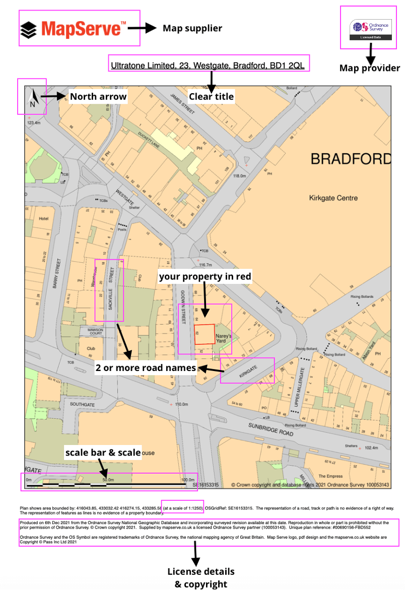
An example of a location plan and what needs to be included in both location and site plans
Other documentation to submit
Along with your site and location plans which you can get on our website, you also need to submit the following documentation, subject to relativity with your project.
- Elevations of both the current and planned designs
- A certificate of ownership.
- A message about design and accessibility.
- A 'Certificate of Agricultural Holdings.' This validates whether any of the land in question is part of an agricultural holding and is required even if your application is for a non-agricultural purpose. The certificate may be found in the forms part of your application.
- The correct charge.
How much does planning permission cost?
The cost of obtaining planning approval varies based on where you reside in the United Kingdom. However, the current expenses are as follows:
Scotland
Get a quote through the official website.
Wales
- Application for a new dwelling costs £380.
- A householder application costs £190.
- Outline applications for 0.1 hectares cost £380.
England
- A comprehensive application for a new dwelling costs £462.
- A request for an extension (also known as a householder application) costs £206.
- An outline application for 0.1 hectare costs £462.
How long does planning permission last?
In most circumstances, planning permission is valid for three years starting on the date that full consent is given. This means that you must commence construction work within this time frame. Once work has formally begun (following the first building rules inspection), planning authorisation is permanent.
10 tips to make sure your planning maps are correct
When using mapping provided by the Ordnance Survey (such as the maps provided by MapServe®) for planning purposes, you should make sure that:
- Your document is not provided by the Land Registry.
- Your plan is only used for one planning application and not multiple ones.
- The plan displays the OS Crown copyright symbols and text.
- Your plan should not be a photocopy or a screenshot.
- If you prefer to use handmade maps – such as standard sheets – they must not be copied from current OS mapping.
- If you want to print or reproduce maps for applications, you must show the relevant licensing number.
- Make sure that the license number of the OS provider is available and/or displayed on your documents. Our OS partner license number is 100053143.
- The recommended size of your plans is either A4 or A3.
- The plan you are using is within the time frame of the license provided by the supplier. All of our plans come with a one-year license. You need to contact us if you need your license extended.
- Stay in touch with your planning officer and ask them any questions you have prior to submission in order to avoid delays and the need for resubmission of your documents.