What is OS MasterMap®?
The beginnings of the Ordnance Survey (OS) were formed in military planning following a rebellion in the Scottish Highlands in 1745. As the government grew increasingly concerned about the French Revolution, the defence ministry was directed to initiate a reconnaissance of England's most vulnerable southern ports in order to safeguard the nation. That's how the Board of Ordnance was born. After more than 250 years OS's cartographic techniques have evolved greatly giving us its most significant product, MasterMap®.
OS MasterMap® is the Ordnance Survey's major digital product, debuted in November 2001. It is a database that records every fixed feature of the United Kingdom that is greater than a few metres in a single continuous digital map. OS MasterMap® is the foundation upon which future Ordnance Survey products will be built. It was initially known as the Digital National Framework or DNF. OS MasterMap® framework's primary notion is the closer link between real-world objects and information stored in the OS spatial database. Currently, the Ordnance Survey produces four levels of MasterMap® data. Every feature is assigned a unique TOID (TOpographical IDentifier), which is a simple identifier with no semantic meaning. Each TOID is paired with a polygon shape that using National Grid coordinates, reflects the area on the ground that the feature covers. Thousands of customers in government, the public and commercial sectors rely on OS MasterMap® every day.
OS MasterMap® is available for the UK here
OS MasterMap® with 1m contours layered on top
What can it be used for?
OS MasterMap® was created to serve a wide range of professional requirements such as:
- geographical analysis
- geographical referencing
- data association
- land management
- route planning
- cartographic representation
- figuring out a site's access points
- property development
- environmental monitoring
- risk assessment
- tourism
Updates and Accuracy
Because of ongoing examination, Ordnance Survey makes sure that OS MasterMap® data is never more than six months out of date. This mapping effort is one of a kind in terms of scope and detail. OS MasterMap® Topography layer updates usually take place every 2 weeks. You can check here for OS MasterMap® refresh dates. So far, around 440 million TOIDs have been assigned, and the database is 600 terabytes in size.
| Original Survey Scale | 99% confidence level | 95% confidence level | RMSE* |
| 1:1250 | |||
| Absolute accuracy* | 0.9 m | 0.8 m | 0.5 m |
| Relative accuracy* | +/- 1.1 m (up to 60 m) | +/- 0.9 m (up to 60 m) | +/- 0.5 m (up to 60 m) |
| 1:1250 | |||
| Absolute accuracy | 2.4 m | 1.9 m | 1.1 m |
| Relative accuracy | +/- 2.5 m (up to 100m) | +/- 1.9 m (up to 100 m) | +/- 1.0 (up to 100 m) |
| 1:10000 | |||
| Absolute accuracy | 8.8m | 7.1m | 4.1m |
| Relative accuracy | +/- 10.1 m (up to 500 m) | +/- 7.7 m (up to 500 m) | +/- 4.0 m (up to 500 m) |
*Absolute accuracy: how closely the coordinates of a point in the dataset agree with the coordinates of the same point on the ground (in the British National Grid reference system).
*Relative accuracy: positional consistency of a data point or feature in relation to other local data points or features within the same or another reference dataset.
*RMSE (root mean squared error) is the square root of the mean of the squares of the errors between the observations.
All data provided by the © Ordnance Survey
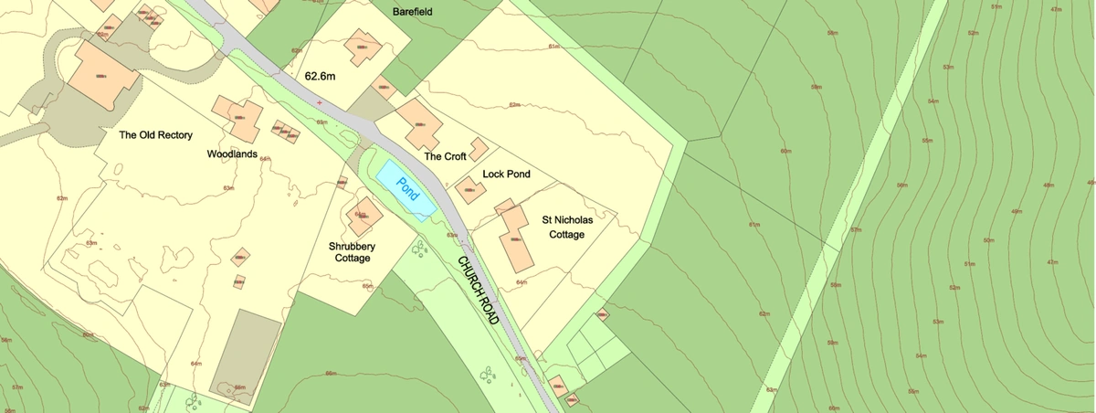
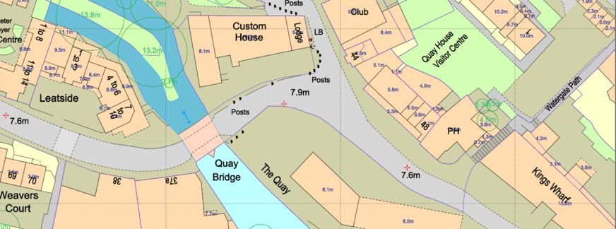
OS MasterMap® Topography layer
Buildings, roads, tracks, walkways, railroads, rivers, lakes, ponds, constructions (such as oil storage tanks and pylons), and land parcels are examples of OS MasterMap® topographic features. Non-topographic information such as administrative and electoral boundaries, cartographic text and symbols, and postal addresses are also included in the data.
It is developed for cartographic representation at 1:1250, 1:2500, and 1:10,000 scales in urban, rural, and mountain/moorland areas, respectively. In GIS OS MasterMap® may be viewed at a variety of scales. Cartographic text and symbol features, which are the most scale-sensitive, are fixed in size and soon become less clear at smaller display scales when zoomed out.
OS MasterMap® with building heights and the National Tree Map™ layered on top
Themed data explanation
A theme is a set collection of features that customers can collectively select. A feature can belong to any number of themes. All of the features included in OS MasterMap® are related to at least one theme. MasterMap® topography layer currently has 9 themed layers:
- Administrative boundaries: The limits of responsibility and representation defined for electoral and administrative purposes.
- Buildings: Roofed constructions, usually walled. Includes permanent roofed constructions that exceed 8.0 m2 in area (12 m2 in private gardens). Exceptions are made for smaller buildings in such a detached position that they form relatively important topographical features. Mobile homes, residential caravans and so on are not captured. Storage tanks may be classified as buildings.
- Heritage and antiquities: Features and cartography which depict sites or constructions of historic interest. This theme is currently very limited in content.
- Water: Features that; contain, delimit or relate to real-world objects containing water.
- Land: Man-made and natural features that delimit and describe the surface cover other than communication routes and buildings. This also includes all features relating to man-made and natural slope and cliff. All General features are also placed in the land theme.
- Rail: Features related to travel by railway or tramway. All features have been identified as part of the rail network. Currently, railway tunnels are not classified as railway and so will be present in the Structures theme.
- Roads tracks and paths: Features related to transport by vehicles, cycles or pedestrians. This includes features that are road, made paths or text classified as road, track or path related.
- Structures: Man-made constructions that are not buildings. These may or may not obstruct passage at ground level.
- Terrain and height: All current height information is included in OS MasterMap® defining ground level. This is currently very limited.
MapServe®'s use of OS MasterMap®
We sell , in a variety of formats including CAD (DWG and DXF), GIS (GML) and raster (PDF and PNG). We also an option to purchase a summarised version with the key layers, called 'Standard' and a version with up to 67 layers called 'Professional'. We also offer optional layers, that are not part of MasterMap® such as 1m contours, freehold boundaries and listed buildings. The price for the data licence is determined by the following factors:
- the total area requested
- the number of layers
- the number of TOIDs in the layers
- the time of data usage in years
Our licence lasts 1 year from the day of purchase. Please contact support if you need to renew your license. Click here to see MasterMap®'s key.
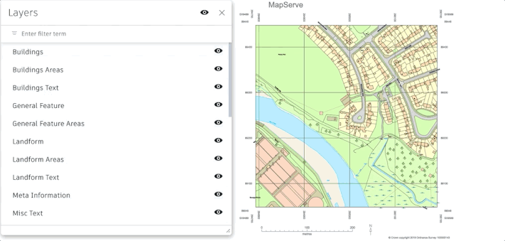
OS MasterMap® Layers