What is an Architectural Site Plan?
An architectural site analysis is the process of examining a certain location's physical, mental, and social qualities in order to design an architectural solution that addresses and improves both its internal and exterior environment. It is focused on researching and comprehending many settings of the project location, such as historical, legal, geographical, climatic, and so on. The analysis's goal is to establish whether or not the project is realistically possible.
The results of an architectural site analysis are often presented in the form of diagrams or drawings. An accurate and thorough investigation of numerous aspects impacting the site will aid in the resolution of multiple construction issues, including the structure's design and layout, placement, and others. As a result, an architectural site study is the critical first step in any building process.
Create an initial site analysis of your site using our site analysis map
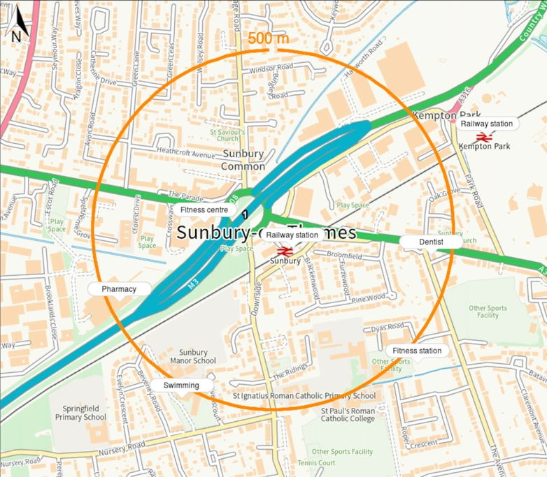
Use of our site analysis map showing local transport, educational institutes, leisure and health institutions around a site
Why is a site analysis necessary?
Investors and customers will want to know if building on a site is feasible, before starting the design process. A detailed site analysis will determine if development is financially viable and will create guidelines for implementing the optimum design that responds to the physical and environmental elements of the site.
A contextual analysis is a research activity that examines the current conditions of a project location as well as any prospective future conditions. The goal is to tell us about a site before we begin our design process, so that our early design thinking about a site may include deliberate answers to the external conditions.
Investors and customers are keen to assess the financial viability of a potential development, and this is precisely where the site analysis checklist comes into play. By examining factors such as site location, size, geography, zoning, traffic patterns, and climate, it provides valuable insights into the feasibility of the project.
Understanding the context of a site is critical for the designer to be able to incorporate the new design into the current fabric of the site. It can help designers to get a deeper understanding of the existing conditions that surround the chosen location, encompassing not only the physical attributes of the site but also the context provided by the existing landscaping and buildings.
8 reasons why a site analysis can help your project
- It helps clients maximise their return on investment by allowing them to assess the feasibility of a project in advance.
- It helps in the reduction of time spent on conception and visualisation.
- Site evaluations also aid in the early resolution of any concerns, averting more serious ones later on.
- Clients demand information on the status of the construction project, which the site analysis gives.
- Site evaluations also aid in the early resolution of any concerns, averting more serious ones later on.
- The project team can make informed decisions about a project based on accurate information.
- Taking into account future variables will aid in the development of an adaptable design.
- Every project is unique, and site analysis assists in identifying one-of-a-kind chances.

What information is important to include in a site analysis?
A site's climatic, geographical, historical, social, legal, and infrastructural environment should all be considered. Visual representation of the site in the form of annotated images, early drawings of the site, site mapping, and site analysis diagrams should be included in the presentation of site analysis.
Here is a generic list of what can be included in your site analysis:
- Site area in square meters or another appropriate measurement
- The location of the project
- Climate/general weather of the area
- Sun path
- Neighbourhood information that includes landmarks, highlights, residences etc.
- Access points
- Social and community information
- Roads, alleyways, buses, trains, and other modes of transportation
- Trees, slopes and natural characteristics of the site
- Any future plans for the area
- Windows or doors that should not be blocked
- Building heights of the buildings in the vicinity of a project
- Shadow analysis
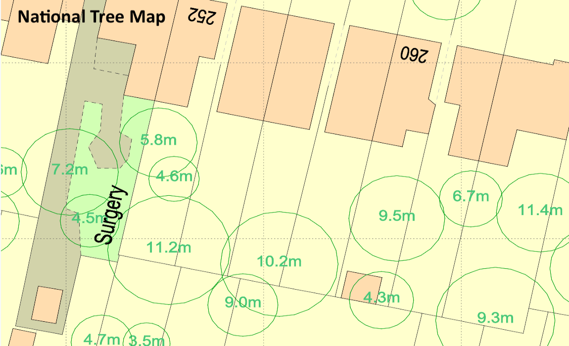
Get the position of all trees above 3m in height in England and Wales using our National Tree Map™
How can MapServe® help you create your site analysis?
We have the latest OS MasterMap® update provided by the Ordnance Survey. OS MasterMap® is the most detailed and up-to-date map in the UK and it is a great base map for your site analysis as it contains over half a billion roads, buildings, parks, and waterways and real-world items with unique identifiers.
Additional layers can be added to OS MasterMap®'s CAD format such as:
- Building Heights
- National Tree Map™
- 1m contours
- Freehold boundaries
- UPRNs
All of these can help you create a comprehensive site analysis with all the necessary information about your project. In addition to this our Site Analysis Map can automatically create an initial site analysis for your site within minutes. The features that can be included:
- transport information (airports, railway stations and lines, roads etc)
- health
- leisure
- educational institutes
You can register and access our maps and Site Analysis Map here.

How to represent your findings on a site analysis
Diagrams are the greatest method to show most of the data you've gathered. There are several techniques to convey the site's qualities. Some like to incorporate as much information as possible on a single diagram, while others will create a series of smaller diagrams to highlight certain site circumstances or attributes. When choosing to place all the data on a single design, it's crucial to ensure that the access point to the information is clear and not overwhelming for the viewer. A single, comprehensive diagram encompassing existing buildings and various site conditions can provide a more holistic perspective compared to numerous discrete diagrams showcasing individual site elements. It is also critical that the drawing's hierarchy is obvious — use different pen thicknesses to represent the different parts.
Data from your site visit can be represented as plans, elevations, and sections, isometrics, or perspectives. Make sure to select the best solution for the data you're attempting to explain. We want to make sure the diagram is basic and clear, with the data we're presenting visually bolder than the reference data. The focus should be on the information you are expressing, such as a path across the property or the location of trees on the site. If you decide to make a series of drawings, make sure that each site picture is always the same orientation and, preferably, scale so that the reader can readily comprehend the drawings.
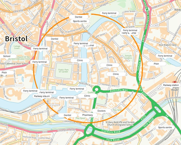
Example of an area using our new 'Site Analysis Map'
A project's components should be kept in mind by architects as they are the best method to express the idea of a structure. Understanding and familiarising with the context can help prepare for the start of the design process. Studying the site's historical context and material circumstances will help establish a proposal for a project. Using an architectural site analysis also aids in the schematic design or programming phases. A properly conducted research of an area reflects the demands of the community where the project is to be executed. Any architectural project's success may be effectively measured by how well it serves the needs of the people who will be most affected by it.