We are excited to announce the addition of three new mapping datasets to MapServe®:
- OS MasterMap® Highways Network
- OS MasterMap® Paths
- OS MasterMap® Waterways
These comprehensive digital maps, provided by Ordnance Survey, offer detailed representations of the road network, paths and footways, and waterways across Great Britain. With precise geometric data and rich attributes, these datasets bring enhanced accuracy and depth to your mapping needs.

OS MasterMap® Highways Network
OS MasterMap® Highways Network is an extensive and highly detailed digital mapping dataset that offers a comprehensive representation of the road network across England, Scotland, and Wales. Developed and maintained by the Ordnance Survey, the national mapping agency of Great Britain, this dataset serves as a vital resource for a wide range of industries and organisations. It contains fully detailed road geometry with important unique identifiers, such as Unique Street Reference Numbers (USRNs) and topographic identifiers (TOIDs), that enable data linking compared to road and street networks. The dataset is updated every month and it is supplied at a range of scales starting at 1:1250 up to 1:10000 scale.
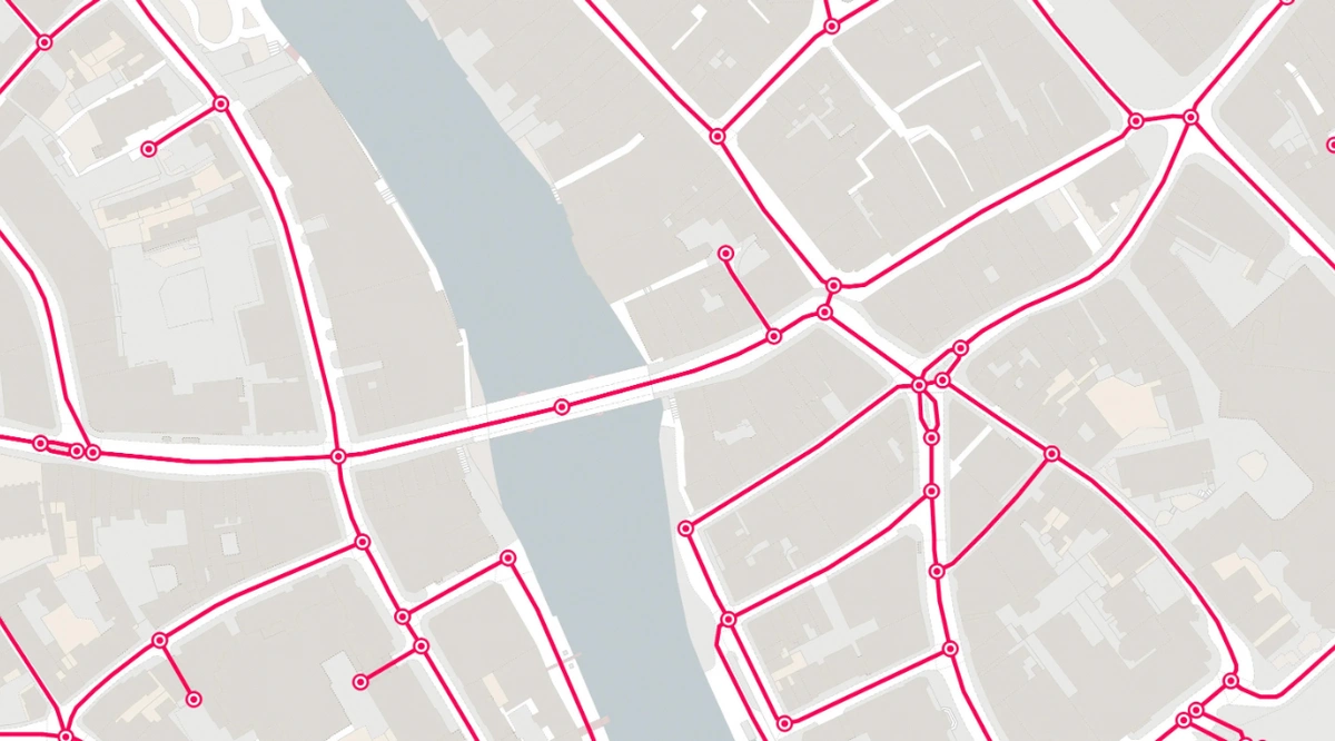
At its core, OS MasterMap® Highways Network provides an intricate depiction of roads, encompassing major highways, local roads, motorways, junctions, and roundabouts. The dataset goes beyond basic road geometry, offering a wealth of additional information that aids in understanding and analysing the road network. This includes road classifications, road names, road numbers, speed limits, lane details, and various other road-related attributes.
The dataset's rich and comprehensive nature extends to features beyond the roads themselves. It incorporates additional information such as road surface types, road signs, traffic signals, pedestrian crossings, and other relevant road infrastructure details. This wealth of data enables diverse applications, benefiting multiple sectors and disciplines.
Various organisations and industries rely on OS MasterMap® Highways Network for a multitude of purposes such as:
- Government agencies and local authorities utilise it extensively for transportation planning, infrastructure management, and policy-making. By leveraging the dataset's detailed information on road classifications, lane details, and speed limits, transportation planners can make informed decisions regarding road networks, traffic flow optimization, and the allocation of resources.
- Emergency services heavily rely on OS MasterMap® Highways Network to efficiently navigate and respond to incidents. The dataset's accurate representation of the road network aids emergency service personnel in determining the most optimal routes, ensuring swift and effective response times.
- Utility companies benefit from the dataset as well, using it to plan the installation and maintenance of their networks, such as gas, water, and electricity supply lines.
- Mapping and navigation applications draw upon the Highways layer to provide accurate and up-to-date route guidance for drivers. By integrating the dataset's detailed road information, including road names, numbers, and lane details, these applications offer users reliable and precise directions. Furthermore, the dataset supports network analysis, enabling researchers and analysts to investigate traffic patterns, congestion hotspots, and the impact of proposed road developments.
In summary, OS MasterMap® Highways Network is an invaluable digital mapping dataset that offers a comprehensive representation of the road network across Great Britain. Its wealth of detailed information on roads, junctions, roundabouts, road classifications, and other related attributes makes it an essential resource for transportation planning, infrastructure management, emergency services, utility companies, navigation applications, and spatial analysis.
OS MasterMap® Paths
OS MasterMap® Paths is a digital mapping dataset provided by the Ordnance Survey, the national mapping agency of Great Britain. It offers a detailed representation of the path network across England, Scotland, and Wales. This dataset provides valuable information about footpaths, bridleways, cycle paths, and other public rights of way. The dataset is updated every month and it is supplied at a range of scales starting at 1:1250 up to 1:10000 scale in vector format.
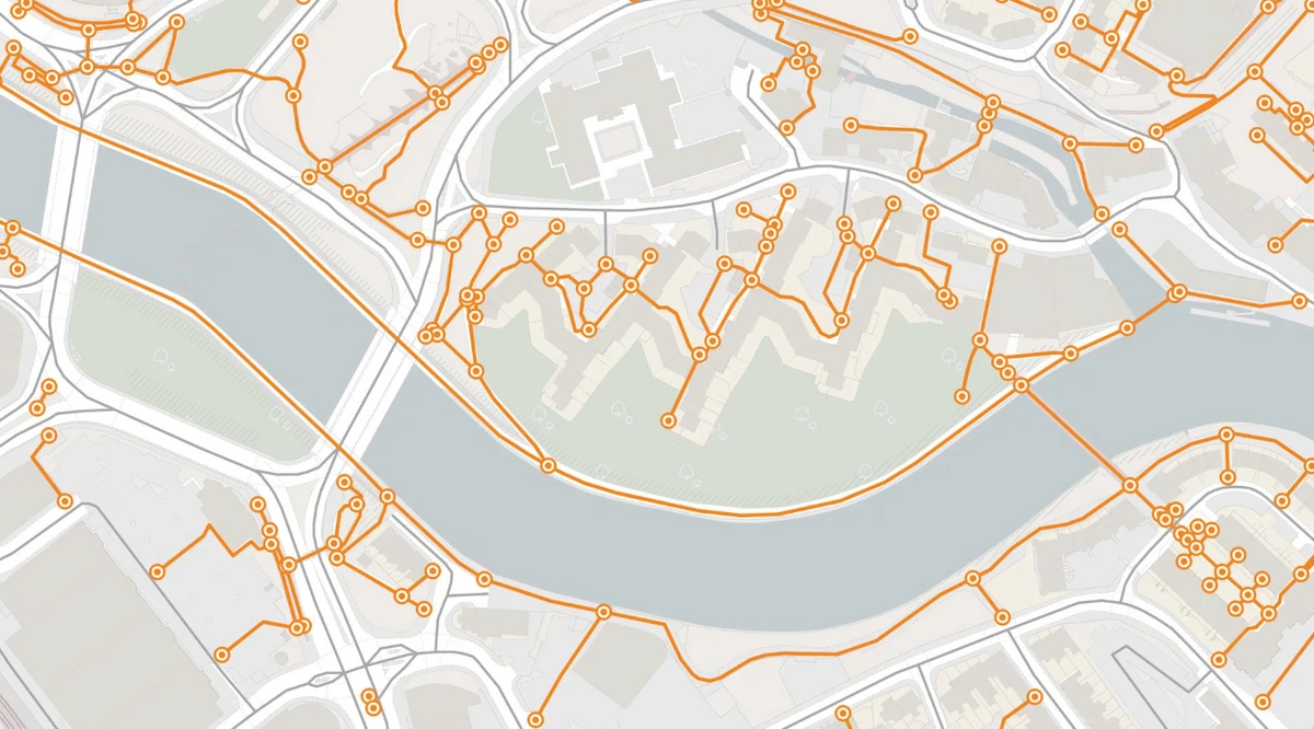
OS MasterMap® Paths includes a variety of path types, such as urban walks, rural trails, long-distance routes, and recreational paths. It provides precise geometry data, allowing for accurate path network mapping and analysis. Path names, classifications, access restrictions, and surface kinds are also included in the collection, offering a thorough overview of the path system.
- The primary purpose of OS MasterMap Paths is to support planning, navigation, and recreational activities. Local authorities, government agencies, and land management organizations use these data to manage and develop path networks effectively. It aids in land use planning, infrastructure development, and the implementation of policies related to public access and recreational opportunities.
- For navigation and outdoor enthusiasts, OS MasterMap® Paths is a valuable resource for route planning and exploration. It helps hikers, cyclists, and horse riders identify paths suitable for their activities, ensuring a safe and enjoyable outdoor experience. The dataset's attributes, such as surface types and access restrictions, provide users with crucial information for selecting appropriate routes.
- It can also promote active travel and support sustainable transportation initiatives. It contributes to the development of cycling infrastructure, pedestrian-friendly routes, and multi-use paths, facilitating healthier and more environmentally friendly modes of transportation. Moreover, the dataset aids in the maintenance and conservation of the path network.
- Land management organisations and conservation groups can get the detailed information provided, to identify areas requiring maintenance or restoration efforts. It supports the preservation of historical paths, protection of ecologically significant areas, and management of access rights.
OS MasterMap® Waterways
OS MasterMap® Networks - Water Layer offers a detailed representation of water features across Great Britain. This dataset plays a crucial role in various industries and applications, providing valuable information for environmental management, planning, infrastructure development, and leisure activities. The dataset is available in vector format and updated every January, April, July and October.
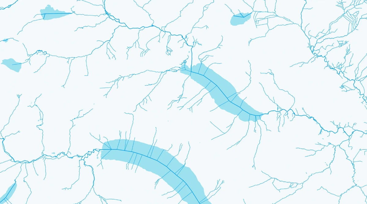
The Water Layer of OS MasterMap® Networks provides precise geometric information about rivers, canals, lakes, reservoirs, and other water bodies. It includes attributes such as names, classifications, flow directions, and depths, enabling a comprehensive understanding of the water network. This dataset serves as a valuable resource for environmental management, facilitating assessments of water resources, monitoring water quality, and supporting conservation efforts and it can be useful for the following:
- Researchers and analysts can use the dataset to study hydrology, model floods, and gain insights into the ecological aspects of water bodies.
- Local authorities and government agencies benefit from the Water Layer in their planning and development initiatives. It aids in land use planning, infrastructure projects, and flood risk assessments by offering detailed information about water features. The dataset helps decision-makers understand the impact of proposed developments on the water network, ensuring sustainable and informed decision-making.
- Utility companies and water service providers can use the Water Layer to manage water-related infrastructure effectively. It supports the planning and maintenance of water supply and wastewater networks by offering accurate information about the water network. This dataset enables the efficient design and routing of pipelines, ensuring the reliable delivery of water services to communities.
- The Water Layer also plays a role in the navigation and leisure industries. It supports recreational activities such as boating, fishing, and water sports by providing essential information for route planning and identifying access points. The dataset contributes to the safety and enjoyment of waterway users, enhancing their overall experience.
- Furthermore, it enables investigations into river networks, catchment areas, and the interconnectivity of water bodies. Researchers, educators, and students can use the dataset's detailed attributes and geometric information for academic research, environmental modeling, and educational purposes.