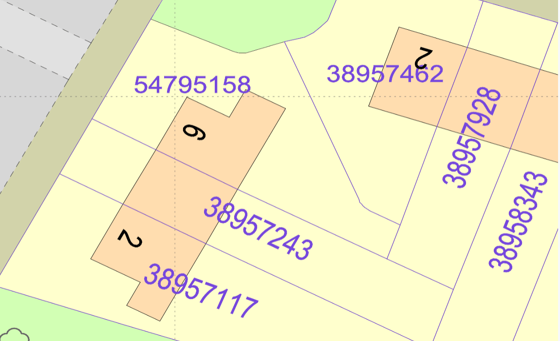
This layer available in DWG and DXF formats is called Freehold boundaries and it contains two extra layers called 'Freehold Lines' & 'Freehold Text' that show the locations of freehold registered property in England and Wales. The polygons are shapes that show the position and indicative extent of a registered property. The numbers shown are called the Land Registry-INSPIRE ID that relates to a registered title. Use a Land Registry-INSPIRE ID with their find a property service to get the title registration and plan for each polygon. The extent of the land contained in any registered title cannot be established from the INSPIRE Index Polygons. This can only be identified from the individual title plan. Each registered title will have a single title number, which may contain several separate polygons. Each individual polygon will have a separate Land Registry-INSPIRE ID. This is an example of how it will appear on your plan.
Freehold boundaries can be downloaded here
If a property or piece of land does not have a Land Registry-INSPIRE ID, it is possible that it is not registered. Alternatively, it could be a leasehold registration or one of the other tenures that are not present in the INSPIRE Index Polygons. The Information is licensed 'as is' and PassincLtd as the 'Information Provider' excludes all representations, warranties, obligations and liabilities in relation to the Information to the maximum extent permitted by law. The Information Provider and/or Licensor are not liable for any errors or omissions in the Information and shall not be liable for any loss, injury, or damage of any kind caused by its use. Please note you are bound by the license terms as linked below.
Interested? Search for the 'Freehold boundaries' optional extra on MapServe®
Uses of Freehold Boundaries in Mapping and Property Transactions
Freehold boundaries are critical in a wide variety of property-related activities, from everyday transactions to large-scale land development projects. They help a wide range of professionals — including surveyors, planners, solicitors, and developers — to understand land ownership and how it affects their work. Below are some common uses of freehold boundaries:
1. Property Development and Planning Applications
For property developers and urban planners, understanding the ownership boundaries of land is essential when preparing development proposals. Freehold boundaries provide clear insights into land ownership, ensuring that proposed buildings, infrastructure, or public spaces do not infringe on neighbouring properties. This is crucial when submitting planning applications to local councils, as accurate landownership information is often a requirement.
In some cases, developers use freehold boundaries to identify adjacent land parcels for potential acquisition, which can be necessary for large developments requiring multiple plots.
2. Resolving Boundary Disputes
Boundary disputes between neighbouring property owners are relatively common, and resolving them often requires an accurate understanding of the legal boundaries. The freehold boundaries layer, when combined with the official title plan from the Land Registry, helps to clarify any ambiguities regarding the extent of a property. However, it’s important to note that while the INSPIRE polygons provide an approximate boundary, they are not legally definitive. Only the title plan is the legal reference for boundary disputes.
3. Due Diligence in Property Transactions
When purchasing property, buyers need to carry out thorough due diligence to ensure there are no hidden surprises regarding ownership or land boundaries. Freehold boundaries provide prospective buyers with a clear view of the land they are purchasing and ensure that it matches the registered title. This can prevent complications later down the line, such as discovering that part of the property is not included in the sale or that there are overlapping claims on certain areas.
Additionally, solicitors involved in property transactions often consult freehold boundaries to confirm land titles and to ensure there are no discrepancies that could affect the conveyancing process.
4. Land Assembly for Large Developments
For large-scale developments, such as housing estates or commercial developments, understanding the layout and ownership of multiple land parcels is vital. Developers use freehold boundaries to identify who owns each piece of land and to map out a strategy for acquiring the necessary parcels for development. Having this data on hand ensures that land assembly is handled smoothly, and the developer knows exactly which titles and owners to approach.
The boundaries also help developers understand any potential restrictions or easements that might affect the use of the land.
Technical Aspects of Freehold Boundaries
The Freehold Lines and Freehold Text layers within the freehold boundaries data provide essential detail that adds accuracy and clarity when interpreting the maps. Here's an explanation of these components:
-
Freehold Lines: These lines delineate the outer edges of freehold properties. This layer is crucial in helping users distinguish between different land parcels on a map, particularly in densely built areas where properties are located close together.
-
Freehold Text: This layer contains the Land Registry INSPIRE IDs, which are unique identifiers that can be used to retrieve more detailed property information. Each polygon has a corresponding INSPIRE ID, and this can be referenced to access the legal title information, including the registered title and any associated plans.
Understanding the Limitations of INSPIRE Index Polygons
While the freehold boundaries layer provides valuable information about land ownership, it's important to remember that the INSPIRE Index Polygons are not a definitive representation of legal boundaries. They are indicative in nature and are used primarily for geographic visualisation rather than legal verification.
To understand the precise boundaries of a property, the individual title plan must be obtained from the Land Registry. The title plan contains the legally recognised boundaries of the property, which may differ slightly from the INSPIRE Index Polygons.
Additionally, it’s worth noting that the absence of an INSPIRE ID for a piece of land does not necessarily mean that the land is unregistered. It could be leasehold, or it could fall under one of several tenures not represented in the INSPIRE dataset. For unregistered land, further investigation through legal and historical documents would be necessary to establish ownership.
Importance of Freehold Boundaries in Land Management and Legal Contexts
Freehold boundaries also play an important role in land management, helping landowners, businesses, and local authorities manage their holdings effectively. By providing a visual and technical representation of land ownership, the freehold boundaries layer assists in the allocation of land for agricultural, residential, or commercial use.
For solicitors and legal professionals, accurate boundary data is essential in the context of property disputes and legal transfers of ownership. Whether resolving disagreements between neighbours or facilitating the sale of a complex multi-parcel estate, freehold boundaries provide the foundational data needed to make informed legal decisions.
Licensing and Legal Use of Freehold Boundaries Data
The data provided by the freehold boundaries layer is licensed "as is", and users must be aware that PassincLtd as the 'Information Provider' excludes all warranties, representations, obligations, and liabilities regarding the data to the fullest extent permitted by law. This means that while the data is a valuable resource, users must accept it without guarantees of accuracy or completeness.
Moreover, the Information Provider and/or Licensor are not liable for any errors or omissions in the data and will not be responsible for any loss, injury, or damage caused by its use. Users should also be aware that they are bound by the terms of the licence linked below, and they should ensure they understand these terms before using the data for any commercial or legal purposes.