What is a map scale?
A map's scale is the ratio of a distance on the map to its equivalent distance on the ground. The scale on the map represents the distance between each landmark. On a 1: 1000000 cm scale map, for example, 1 centimetre equals 1 kilometre on the earth. The curvature of the Earth's surface complicates this simple notion by forcing scale to change throughout a map. You can read more about it here.
The latest maps of Great Britain are available here
What are the three types of scales on maps?
1. Fractional or Ratio Scale
A fractional scale map displays a portion of an object or geographic feature on the map. This type employs a series of integers to represent an item or a landmark such as 1:24,000.

A set of map scales from a USGS 7.5-minute Topo map
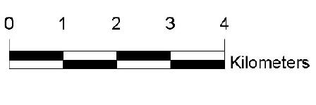
2. Linear Scale
A linear scale depicts the distance between two or more notable locations. On maps, the linear scale is a series of lines or dots that represent a landmark.
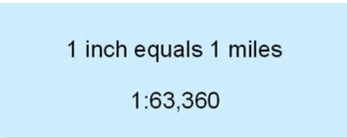
3. Verbal Scale
Simple terms are used to define a noticeable surface feature on this scale. A verbal map scale describes a location or object by expanding abbreviations, for example “One inch to the mile”.
Why are they important?
Precision
A scale displays the actual value of the thing depicted on the map. Accurate landmark information includes facts and figures about the monument. Naming a street, structure, mountain, or road are a few examples.
Geographic analysis
A scale delivers a geographical analysis to a single surface element on a map. The study indicates the significance of the geographical feature as well as the distance between landmarks. The geographical analysis validates the land feature type as a mountain, building, or road.
Time Management
Using a scale saves time and effort while examining the geographical geography on a map. Each scale specifies the landmarks and the geographical distance between them. It is no longer necessary for map readers to perform study in order to grasp landmark geography.
Education
Scales on maps improve anyone's understanding of the geographic intricacies of an object, scene, or geographical position. To avoid misunderstanding, the scale displays the object's true name. Mount Everest, at 8,849 mmetres above sea level, is one such example.
Tourism
Tourists use scale maps to navigate the geography of the monument. The scale map informs tourists about the name of the site as well as the distance between land features. As an example, the map depicts the complete length of the white sand beach, which is 8 kilometres long.
Geometrical Presentation
Using a geometrical presentation increases the visibility of the landmark. There are forms that indicate a landmark's distance, height, and structure. These are clear shapes on the map that symbolize structures and sites.