While the population of the planet is growing exponentially, the land available to accommodate it remains limited. In fact, it is shrinking in size every day. Urbanisation is the new threat the environment is fighting with. Humans are actively intruding all lands but the problem of suitable living conditions for all species remains. Effective and smart urbanisation is becoming a necessity, in order to accommodate more people in less space. Nevertheless, the issue of city planning becomes more complicated with the passing of time. One of the reasons is the infrastructure that is already in place. While we are focused on urban planning today, most of the time we do not have the liberty to modify the infrastructure that was built previously. We can attempt to work around it, but we might need to compromise our urban planning needs at some point, which suggests that we will have to fit these needs around the already existing infrastructure. Geospatial data have become omnipresent. It has infiltrated almost every aspect of our lives today. The aspect of living has been captivated by GIS (geographical information systems) and when the designers use it in urban planning it can take urbanisation to a new level.
Access professional OS mapping here

How can mapping and GIS be used in urban planning?
Mapping data provide architects, surveyors, and engineers with the tools they need to design and map their cities. Visualisation, spatial analysis, and spatial modeling are the most frequently used GIS uses in urban design. GIS can help to store, manipulate, and analyse the physical, social, and economic information of a community. Building professionals can then use the spatial data and mapping functions of GIS to analyse the current circumstances of a city. Through map overlay analysis, GIS can help to pinpoint areas of conflict of land development with the environment by overlaying existing land development on land suitability maps. Architects and make use of GIS to ease the progress of citizen participation and community input as they develop a vision for the community that elevates the quality of life for all citizens. Citizens are the core of any city and first-hand inputs from them as to what can be done to make their city smarter can help in crafting out amazingly productive methods/means for urban planning. PPGIS (public participatory geospatial data) platform software allows effectively this citizen involvement procedure.
What is mapping data used for in urban planning?
Mapping software promotes a good public image of a planning department. Planning professionals can access quickly all kinds of data, such as environmentally sensitive areas, and all matters concerning the implementation of zoning, permit status, and other planning information. Architects and urban designers use the software to prepare site plans, which set the standard for policy decisions regarding long term changes to a community’s physical environment. The different tools available through the software help building professionals to analyse problems more quickly and thoroughly, create solutions, and monitor progress toward long-term goals for the community. Geospatial information is also used by architecture offices to conduct an environmental analysis of projects; development review, analysis, and compliance; historic preservation; and redevelopment, as well as regional planning, as more planning agencies try to coordinate planning efforts in order to minimise negative impacts on neighbouring communities. In many cases, planning agencies are also using mapping services to coordinate planning and economic development initiatives.
Among the reasons why mapping software is essential in urban planning is the ability to better comprehend the current needs of a city, and then design to realise those needs. By processing geospatial data from satellite imaging, aerial photography and remote sensors, users have access to a highly detailed perspective on land and infrastructure. As urban populations become denser the importance of geographical data lies in its ability to pull together the huge amounts of information necessary to balance a city’s complicated problems and solve them, such as optimising the placement of new developments or determine the practicality and placement of a waste disposal site.
Common applications of geospatial data
- Review and analysis of plans for development.
- Checks on regulatory compliance.
- Review of environmental impact.
- Preservation of historic sites.
- Regional planning beyond the borders of a city or town.
- Mapping the delivery of utilities and planning for service interruptions.
By performing land use analyses, planners can direct new developments to areas that are less susceptible to destruction from natural disasters. Combining geographic and financing information data might lead to reenergising an urban area in need of new business.
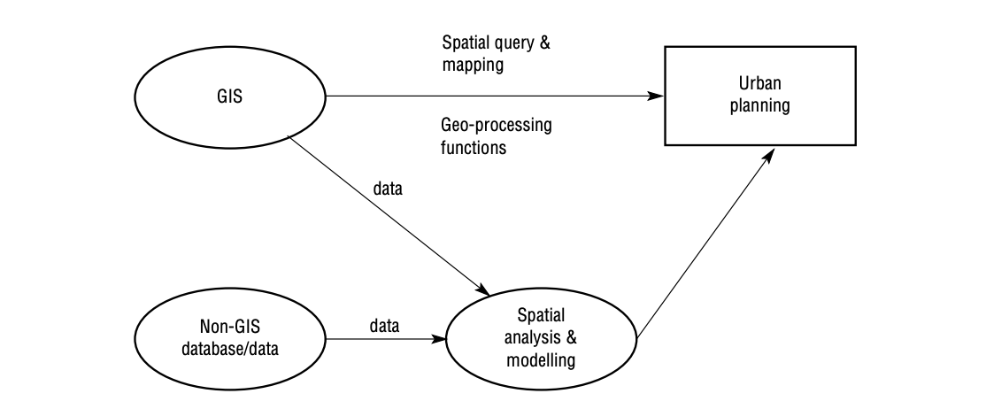
fig. 1 (University of Edinburgh, School of Geosciences)
Mapping software is progressively being used in building design companies both in developed and developing countries. Probably every planning department uses mapping systems. With the increased user-friendliness and the number of functions of the software, and the noticeable price reduction of mapping hardware, it has come to be an operational and affordable information system for planning. It is increasingly becoming a principal element in the planning support system. Recent advances in the integration of mapping software with 2D and 3D architecture models, visualisation, and the Internet will make it even more indispensable to urban planning.