Mapping is an important tool in architecture because it enables designers to visualise and comprehend complex spatial relationships. Architects can analyse elements such as terrain, climate, and access to infrastructure by making precise maps of a building site or urban region, which informs the design process. Mapping can also assist architects in identifying potential barriers to innovation and opportunity, allowing them to make educated judgements about materials, structural systems, and circulation patterns. Here are 10 ways mapping is used in architecture:
Download the latest update of OS MasterMap® here
1. Site analysis
An architectural site analysis is the process of examining the physical, mental, and social features of a specific location in order to build an architectural solution that addresses and enhances both its interior and external surroundings. It focuses on investigating and comprehending several aspects of the project area, such as historical, legal, topographical, and climatic factors, among others. The purpose of the analysis is to determine whether or not the project is feasible.
Architects use different maps to analyse a site for a proposed building project, including topography, vegetation, access, and neighboring structures. We provide the latest update of OS MasterMap® which can be used as the base map for a detailed site analysis. Additional layers can be added to OS MasterMap®'s CAD format such as:
- Building Heights
- National Tree Map
- 1m contours
- Freehold boundaries
All of these can assist you in creating a comprehensive analysis study with all of the relevant information regarding your project.
2. Land use and zoning
In architecture, zoning regulations analysis is the study of the local and national legislation and rules that affect the usage and development of a property. The purpose of zoning regulations analysis is to understand the constraints and requirements that apply to a site and to design a building and its surrounding landscape that adheres to all applicable regulations. Creating and examining a local zoning map to establish the designated zoning area for the site as well as the limits and requirements that apply is an important stage in a zoning rules study.
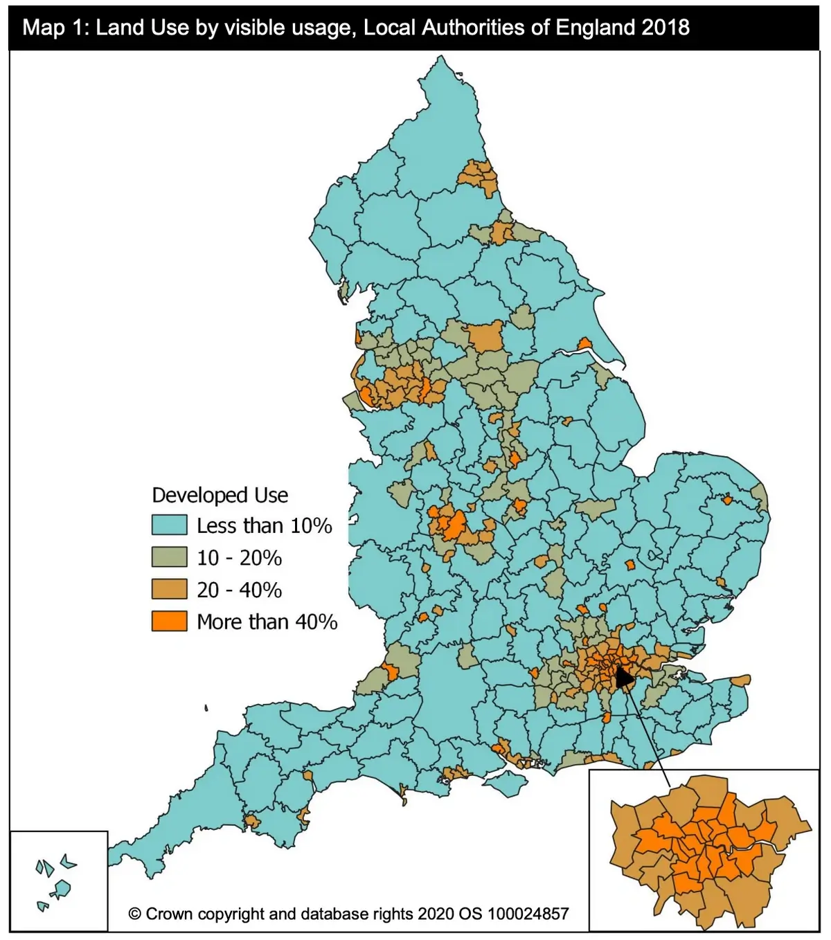
Ministry of Housing, Communities and Local Government
3. Historical maps
Historical mapping can help architects gain a better understanding of the context of a site, including its historical land use, topography, and surrounding landmarks. This knowledge can inform their design decisions, ensuring that the building they create is harmonious with its surroundings. Additionally, historical maps can provide architects with valuable information about the materials and construction techniques used in the past, which can be useful in the preservation and restoration of historic buildings. Finally, architects can draw inspiration from historical maps, using them as a starting point for their designs or to inform the layout of public spaces. Overall, historical mapping is an important resource for architects looking to create buildings that are both functional and respectful of their surroundings and history. Our OS historical maps start in the 19th century and can be used to analyse changes in our towns and landscape over time to learn about the past.
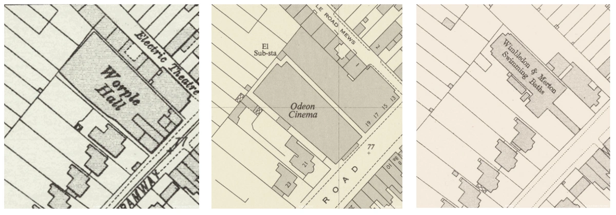
OS Historical Maps
4. Building footprints
Mapping can be an essential tool for architects when studying the footprints of existing buildings. By creating detailed maps of a building's footprint, architects can gain a better understanding of the structure's layout, as well as identify potential areas for improvement or expansion. There are a few key steps involved in the process of using mapping to study a building's footprint.
First, architects will typically begin by creating a site plan, which is a detailed map of the building and its surroundings. This plan will include information on the building's size and shape, as well as the location of any surrounding structures or features, such as roads or parking lots. From there, architects may use various mapping techniques to create more detailed maps of the building's interior and exterior spaces. This can include creating floor plans, which detail the layout of each floor of the building, as well as elevations, which show the building's exterior from different angles.
Once these maps have been created, architects can begin to analyse them to identify areas of the building that may need improvement or renovation. For example, they may notice that the layout of the building's interior is inefficient, or that certain spaces are too small or too large. They may also identify areas where the building's structure or systems are outdated and in need of an upgrade.
In addition to identifying areas for improvement, mapping can also be useful for architects who are looking to expand or renovate existing buildings. By studying the building's footprint, architects can identify areas where new spaces could be added or where existing spaces could be expanded. They can also use mapping to create 3D models of the building, which can be used to test out different design ideas and visualize the potential impact of proposed changes.
5. Public transportation
Architects can use maps to identify public transportation options near a building site, which can have a significant impact on the design of the building and its accessibility for users. By analyzing maps of the surrounding area, architects can identify the location of nearby bus stops, train stations, and other forms of public transportation, as well as the routes they take and their schedules. This information can then be used to inform the design of the building, ensuring that it is easily accessible to those who rely on public transportation. For example, architects may choose to locate the main entrance of the building near a bus stop or train station or to include covered walkways or other amenities that make it easier for users to get to and from the building in inclement weather.
Designing a building with public transportation in mind can also have environmental and social benefits. By encouraging the use of public transportation, architects can help reduce the number of cars on the road, which can lead to lower carbon emissions and improved air quality. It can also make it easier for people to access the building, regardless of their socioeconomic status, which can help promote greater social equity.
6. Pedestrian and bike infrastructure
Architects can use maps to identify existing pedestrian and bike infrastructure in the area surrounding a building project. This information can be used to inform the design of the building project and promote sustainable transportation options. By identifying existing bike lanes, sidewalks, and trails, architects can design the building to be easily accessible by foot or bike. This can include designing bike parking areas and pedestrian walkways that connect to existing infrastructure, as well as incorporating features such as showers and changing rooms to encourage employees to bike or walk to work. By prioritizing sustainable transportation options, architects can help reduce the carbon footprint of the building and promote a healthier, more active lifestyle for its occupants. Additionally, creating a pedestrian and bike-friendly environment around the building can help to increase foot traffic and support local businesses, further contributing to the sustainable development of the area.
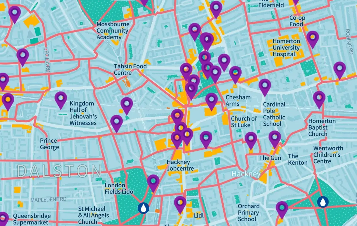
7. Green space and public amenities
By analysing maps of the surrounding area, architects can identify the location of nearby parks, open spaces, and other public amenities such as community centers, libraries, and museums. This information can then be used to inform the design of the building, ensuring that it is well-integrated into the surrounding community and provides easy access to public amenities.In addition to identifying the location of nearby public amenities, mapping can also help architects to understand the surrounding environment and design the building to take advantage of its natural features. For example, by analysing topographical maps, architects can identify areas of high elevation or other natural features that can be incorporated into the building's design. They can also use maps to identify areas of green space, such as parks and open spaces, that can be integrated into the building's design to provide a more natural and sustainable environment for its occupants.
Furthermore, by using mapping to identify public amenities, architects can design buildings that support the health and well-being of their occupants. For example, by identifying nearby parks and open spaces, architects can design buildings with outdoor spaces that encourage physical activity and social interaction. This can include features such as bike racks, walking paths, and outdoor seating areas that connect seamlessly with nearby public amenities and encourage a more active and engaged lifestyle for building occupants.
8. Solar and wind patterns
Understanding the solar and wind patterns of an area, can inform the design of buildings and help maximize their energy efficiency. By analysing solar and wind maps of an area, architects can identify areas of the building site that are exposed to the most sunlight and wind, allowing them to design the building to take advantage of these natural resources. This can include features such as solar panels, wind turbines, and passive solar design elements that capture and utilize solar energy and wind power to reduce the building's reliance on non-renewable energy sources. Additionally, understanding the solar and wind patterns of an area can help architects design buildings that are well-suited to their local climate, providing natural ventilation and lighting that can improve the comfort and health of building occupants while reducing energy consumption. Overall, it is a valuable tool for architects in designing sustainable, energy-efficient buildings that are well-suited to their local environment.
9. Access to utilities
When analysing maps of the building site and surrounding area, architects can identify the location of existing utility lines and infrastructure, allowing them to design buildings that are well-integrated with these systems. This information can also be used to plan the routing of utility lines and connections for new buildings, ensuring that they are connected to the appropriate systems and minimising disruption to the surrounding community. In addition to this, understanding the location of utilities can help architects design buildings that are energy-efficient and sustainable, by ensuring that the building is designed to take advantage of existing infrastructure and minimise the need for additional utility connections.
10. Emergency services
Architects can use maps to identify the location of emergency services such as fire stations, hospitals, and police stations, which can inform the design of a building project to ensure safety and accessibility for users. By analysing maps of the surrounding area, architects can identify the location of nearby emergency services, and use this information to design buildings that are well-suited to their local environment and infrastructure. For example, by identifying the location of nearby fire stations, architects can design buildings with fire-resistant materials and accessible fire exits, ensuring that the building is safe in the event of a fire. Similarly, by marking the location of nearby hospitals and emergency medical facilities, when designing new projects, easy access to these services can be prioritised, ensuring that building occupants can receive medical attention quickly and easily in the event of an emergency.
This way architects can design buildings that support the safety and well-being of their occupants. For example, by identifying the location of nearby police stations, architects can design buildings with secure entrances and other security features, ensuring that the building is safe and secure for its occupants. This can include features such as video surveillance, secure access controls, and emergency call systems that connect directly with nearby emergency services.
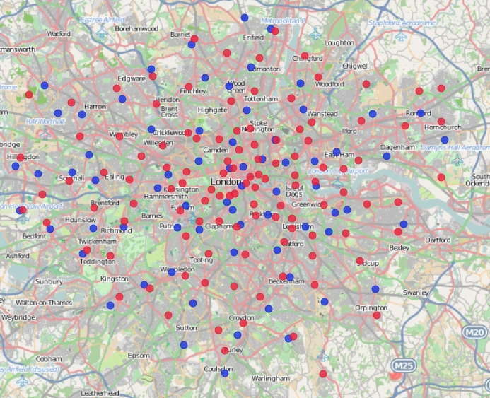
Ambulance (blue) and Fire Stations (red) in London by Spatiametrics